
Enjoy the spectacular scenery on the drive from Homestead to Flamingo in Everglades National Park by stopping at a variety of amazing locations on this route. The journey will take you through three distinct ecosystems of Everglades National Park. Coastal mangroves, sawgrass marshes, and pine flatwoods hammocks make up the Everglades ecosystem. The main road from Ernest F. Coe Visitor Center to the Flamingo Visitor Center follows the Ingraham Highway, traveling 38-miles through each of the three distinctive Everglades ecosystems.
This post may contain affiliate links, meaning if you purchase something through one of these links, we may earn a small commission at no extra cost to you! Read the full disclosure policy here

Table of Contents
Homestead-Flamingo Everglades Road Trip: Important to Know Before You Go
- Entrance Fees: Everglades National Park charges an entrance fee. It is $15 per person ($30 per vehicle) and is valid for 7 days. If you are planning on visiting more than one national park, it is worthwhile to purchase the Annual Pass ($80). It is well worth the price! We purchased a senior pass. These fees support the national parks.
- Operating Hours: The park is open 365 days a year.
- Visitor Centers: Stop by the Shark Valley, Ernest F. Coe, Flamingo, or Gulf Coast visitor centers for maps, exhibits, restrooms, and helpful ranger advice. Hours vary by location and season—check the official park’s website or call (305) 242-7700 before you go.
- Cell Service: Limited in most areas—download maps and information before you arrive. GPS may not be reliable deep in the park.
- Pet Policy: Allowed: paved roads, parking lots, campgrounds, picnic areas, near buildings, private boats.Not allowed: trails, boardwalks, Shark Valley, backcountry, visitor centers. Leash required (max 6 ft)
- Before hiking in the Everglades, remember to bring water in a refillable water bottle, sunscreen, bug repellent, binoculars, and a camera are essential for hiking the trails. Furthermore, wear long pants and long-sleeved shirts, and wear waterproof or wading shoes.
- Seasons Matter: The best time to visit is the dry season (Nov–April) when wildlife is active, bugs are fewer, and temperatures are mild. The wet season (May–Oct) brings humidity, afternoon storms, and more mosquitoes.

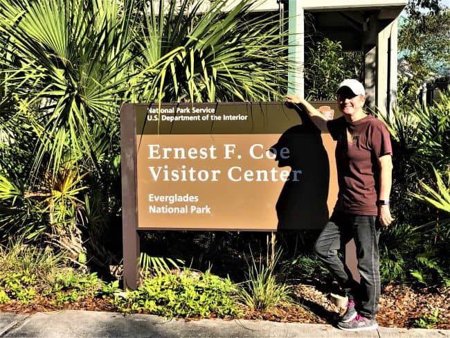
Get Your Scenic Drive Started at the Enest Coe Visitor Center
This is an amazing place with so much to offer. A good starting point for any visitor to the Everglades is one of the visitor centers. There are two visitor centers in the park: the Ernest Coe Visitor Center and the Flamingo Visitor Center. Click here for the Everglades National Park map.
Journey into the Heart of the Everglades for the first time
A journey into the heart of the Everglades is a fantastic opportunity to connect with nature and experience a one-of-a-kind environment. The first stop is the visitor’s center.
Royal Palm Information Center

This is the first stop for most visitors to the Everglades driving from Homestead to Flamingo. The spur road is located 1.6-miles from the park entrance. Follow the spur road 1.9-miles to reach the information center building and parking lot. This area of the park fills quickly. I prefer to visit early in the morning or late in the afternoon. The center is open from 9 am- 5 pm. Their information center provides restrooms, a bookstore, and ranger-led tours.
PRO Tip: The park provides tarps and bungee cords to cover your vehicle. This is to protect your vehicle from the vultures eating the rubber on cars-specifically windshield wipers.

Historic Nike Missile Site HM-69
As you journey through the Everglades, make time to see the historic Nike Missile site. We did not know there was a Nike missile site in the middle of Everglades National Park during the Cuban Missile Crisis. A chilling reminder of how close the US came to nuclear war with the Soviet Union in the mid-1960s.

Tours are daily at 2 PM, December through March. This ranger-led tour takes about 90 minutes. They staffed the facility with volunteers, most of whom they stationed here during the Cuban missile crisis. The volunteers tell their stories and help with maintaining the site. The men stationed here faced appalling conditions, considering the heat and mosquitoes.

Take a tour of the missile site
This tour meets at the Daniel Beard buildings before traveling to the missile site. The only way to see the actual missile site is to take the ranger-led tour. The highlight of the ranger-led tour is the missile assembly building that holds the missiles, including a restored Nike missile! This restored 1960 Nike Hercules Missile was just one of four. The base never fired any missiles. There are three hangar buildings and bunkers at the site. The building contains missile equipment and electronic parts the Army used.
PRO Tip: There is no shade available, no water available, and there are no restroom facilities during the tour. I recommend checking tour times with the park rangers at Royal Palm before driving the 14-miles to the site.

Exploring the Scenic Hiking Trails Along the Road to Flamingo
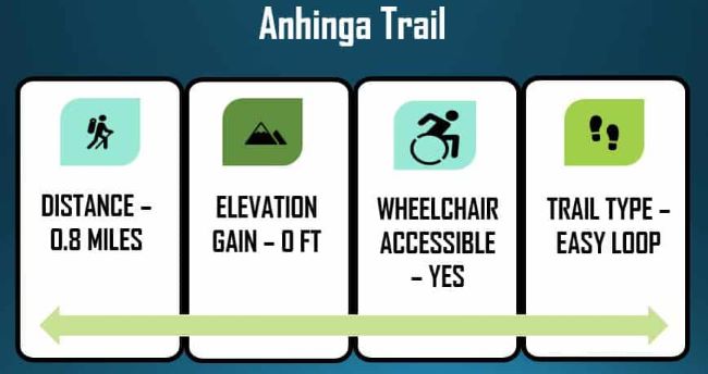
Walk the Anhinga Trail (MM-3.7)
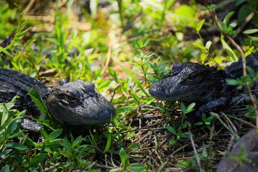
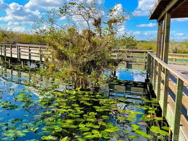
A 0.8-mile boardwalk loop through Taylor Slough offers expansive views of the river of grass. The wide paved walkway leads to a raised boardwalk loop and observation platform over the wetlands. Great opportunity to see a lot of wildlife. This is the best place to see alligators. Even in the dry season, there is plenty of water. We spent most of our time looking for bedding largemouth bass. Most times we are catching bass, not watching them do their mating ritual. It was fascinating as we watched them. If you download the NPS app ahead of your visit, you will have access to the trail map.
TIP: This trail can be crowded because of the proximity to Homestead. I suggest arriving early in the morning or later in the afternoon is best.

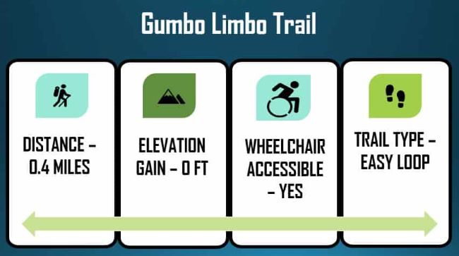
Don’t Miss the Gumbo Limbo Trail (MM-3.7)
This is a 0.4-mile trail through a tropical hardwood hammock. This trail is less traveled compared to the Anhinga Trail. The trail is asphalt-paved and wheelchair-accessible. There are interpretive plaques placed throughout the trail detailing the flora and fauna. They label many of the trees so that you can learn their names. On the trail are a few solution holes. These are formed gradually over time when acidic water erodes or is dissolves the karst limestone. A cool walk to escape the heat of the day. However, mosquitoes are always present in wetland environments.

WARNING: Touching poison ivy and poisonwood can cause reactions; be careful on the trail.

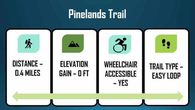
Pinelands Trail: a Diverse Landscape (MM-6.8)
The Pinelands Trail is a 0.4-mile walk through a slash pine forest. They place general information about the flora and fauna of the Pinelands ecosystem on interpretive signs along the trail. Much of the subtropical forest undergrowth comprises saw palmettos, scattered ferns, and other lush vegetation. We saw tree snails and various lizards as we walked along the trail. There are solution holes created when rainwater and decaying leaves combine to dissolve limestone bedrock. Water is stored in a natural pool formed by sinking soil. These provide needed water for wildlife during the dry season. I find the unique geology of the Everglades and Florida to be fascinating. (Long Pine Trail Map)


Cypress Dome Boardwalk – Pa-hay-okee Overlook Trail (MM-14.2)
This is a very short 0.2-mile loop trail that ends with a raised platform where you can view incredible, panoramic of the river of grass. Pay-hay-okee in the Seminole language translates to “grassy waters.” The trail begins in woodland before emerging onto the grassy slough. From the observation deck, you can see the vastness of the Everglades sawgrass marsh. It seems to go on forever in the distance. Trail map-click here.
Travel TIP: If you have the time, this is a great place to view the sunset. The panoramic views of the “River of Grass” are amazing.


A Walk into the “Jungle”- Mahogany Hammock Trail (MM-21.8)
The trail is about halfway between Homestead and Flamingo. This is a 0.4-mile loop through an island tropical forest hammock. A raised boardwalk takes you through the grass wetland to the island jungle. The walk is suitable for everyone, including small kids and those in wheelchairs. There are no facilities in the parking area. At certain times of the year, mosquitoes may be a problem, so bring plenty of bug repellent. I love this trail for its unique perspective on the Everglades. These isolated hammocks are a lifeline for a myriad of species like panthers, bears, otters and migratory birds. Even in the wet season, they provide an oasis.

When we stepped onto the hardwood hammock, many large hardwoods were covered with epiphytes. It amazes me how a small rise in elevation can make a completely unique ecosystem. We saw many trees during our walk, including strangler figs, gumbo limbo trees, and palms. The highlight of this trail is that you will see the largest living mahogany tree (Swieteniamahogani) in the United States. Virtually all the mahogany trees were over-harvested in the early 17th century. They prized the trees for their durability, used for shipbuilding, furniture, and other uses. We found this to be the best hike, probably because we had the hammock to ourselves. It was refreshing to take our time, enjoying the solitude of the moment in this tropical oasis. If you are lucky, you will see a barred owl.

Paurotis Pond Picnic Area-Nesting Bird Rookeries (MM-24.6)
Located 24-miles from the main park entrance in Homestead, Paurotis Pond is a good place to stop and eat a picnic lunch. There are three tables near the shoreline of the pond. Occasionally, the area is seasonally closed for fishing and canoeing due to nesting birds on the island. We saw so many species of birds here. White Ibis, Snowy Egret, Roseate Spoonbill, Wood Stork, Little Blue Heron, Black-Crowned Night Heron, Great Blue Heron, Great Egret, and Anhinga, to name just a few. This aquatic habitat is a crucial nesting area for the endangered wood stork.
Mosquitoes are always problematic in the Everglades; however, in the dry season, they can be tolerable. We enjoyed our picnic and cast a few lures before continuing on our journey south towards Flamingo.

Explore the 9-Mile Pond Canoe Trail (MM 26.5)
We rented a canoe for the day. The canoe trail is a 5.2-mile loop. A ranger-led tour is available most days-check with the visitor center, or you can reserve a canoe at the Flamingo marina. We rented a canoe and picked up paddles and life jackets at the marina. They gave us a combination to unlock the canoe that was already at Nine Mile Pond.
In spite of the fact that today the PVC markers make following the shallow water trail easy, be aware that the white PVC markers aren’t always easily visible. The maze of mangroves, periphyton, and sawgrass at times makes it difficult to maneuver the canoe. Even though it is the dry season, the water levels are higher than usual, and the overcast weather and cooler temperatures keeping the mosquitoes away today. Most on our tour, we did not see much in the way of wildlife because of the poor weather conditions.

West Lake Trail (MM-29.7)
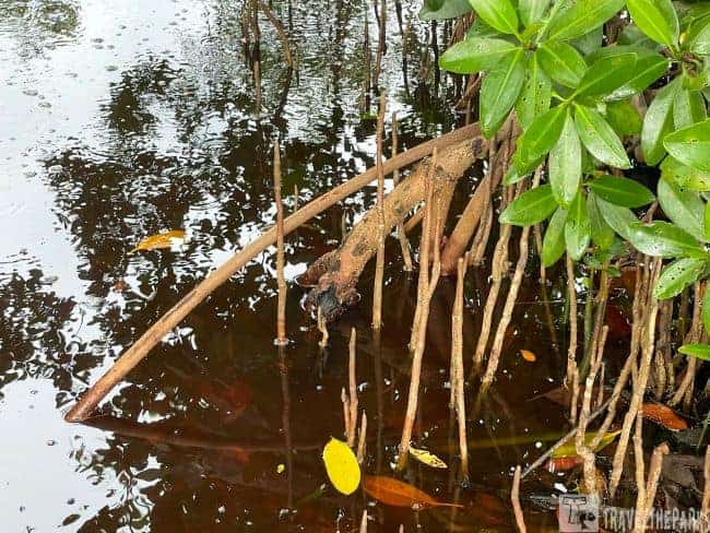
This is a 0.4-mile self-guided boardwalk trail through a mangrove forest, a unique and vital saltwater environment. It damaged much of the boardwalk during the last hurricane, so it is no longer a loop. However, it is still worth venturing to see the lake. The wind also damaged many of the mangroves.

You will see three types of mangroves. There are red mangroves, black mangroves, and a few white mangrove trees. Red mangroves are easy to distinguish from other mangroves. It has roots that hang from the branches, descending to the waterline. The prop roots of all mangroves stabilize shorelines, protecting them from the battering of waves. The prop roots of the mangrove trees are an ideal habitat for juvenile fish, creating a nursery of sorts. Buttonwood is also in abundance along the boardwalk.

Journey through the West Lake Canoe Trail
There is an 8.1-mile canoe trail (one-way) to Alligator Creek, ending at the mouth at Garfield Bight. Watch out for alligators and crocodiles. On a windy day, the lake can be difficult to navigate as the trail crosses the entire length of West Lake. Always check the weather report before hitting the trail. PVC trail markers direct you into Long Lake. Long Lake is more protected as it is long and narrow. From here, follow the PVC markers. It zig-zags through what is called “the lungs” before entering Alligator Creek and emptying into Garfield Bight. It’s an 18-mile round trip, and it’s difficult. Backcountry permits are required if you plan on camping. We never completed the entire trail. However, we got through the first 3-miles before turning back. It is a great way to experience the park.
The boardwalk over the open water is a birder’s paradise, especially in the dry season. We saw many common wading birds, including purple gallinules, limpkins, coots, herons, ibises, and roseate spoonbills. You can view alligators along the boardwalk sunning themselves on cooler winter days. There is also a launch for canoes and kayaks and a covered area for protection from the sun. Great spot to sit and watch the wildlife. This is the first stop with restrooms after leaving the Royal Palm area.

Hell’s Bay Canoe Trail
This peaceful paddle meanders through the mangroves. We rented a tandem kayak for 1/2 day. It was plenty of time to complete the 6.75 mile out & back trail. The trail is marked with white PVS poles to show you the way. It is 3.0 miles to Lard Can backcountry campsite, 3.5 miles to Pearl Bay Chickee, and 5.5 miles to Hell’s Bay Chickee (all require permits to camp). Today, with the brisk wind, we only got as far as Pearl Bay Chickee before the skies began to look foreboding for rain. They say the trek is “hell to get into and hell to get out of.” Bring water, sunscreen, bug spray, binoculars, snacks in a waterproof dry bag. A camera is a must. It really was an enjoyable afternoon, a leisurely paddle. Lots of wading birds and a few alligators.
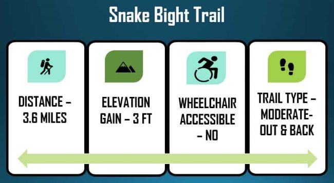
Navigate the Snake Bight Trail (MM-33.1)
A 3.6-mile out & back trail, it’s a straight, flat walk to Florida Bay from the main road. Usually well-traveled, this trail follows the Snake Bight Canal. The dry season is the preferred time to hike the trail because it is cooler. It’s brutal to deal with mosquitoes during the day when it is hot. Even on wintry days, long pants and bug repellent are required. The trail begins in a tropical hammock, giving you lots of shade. This trail can be quite muddy in places. The last section closer to the bay is fully exposed, with little to no shade. Marvellous views of the bay from the boardwalk. Currently, the trail is not maintained by the park service.

Don’t get thwarted by the mosquitoes. If you make it to the end of the trail, you will be rewarded. The bay views are amazing. There are lots of birds to see if the tide is out. Bring binoculars. We saw plenty of roseate spoonbills, white pelicans, and flamingos. The mangroves along the trail are home to flycatchers, warblers, and catbirds. We saw a few alligators sunning, trying to stay warm in the cooler air. I wish we had brought the fishing rods to fish th canal, maybe next time.

Close to the Roadway-Mrazek Pond (MM-34.2)
The pond is located 4 miles north of the Flamingo Visitor Center. It can be a great place for birding. When water levels are low, it can be one of the most exciting birding sites in North America. Throughout the winter months, hundreds of migrating water birds, including ducks, herons, egrets, and white pelicans, frequent the waters. The day we stopped on our return to Homestead, we saw kingfishers and ibises.

Follow the Old Ingram Highway-Rowdy Bend Trail (MM-34.5)
This 2.6 mile out & back trail follows an overgrown roadbed ending at the Snake Bight trail. It can be completed as a loop. It traverses through coastal prairie forest with lowland buttonbush and marsh grasses. Tons of epiphytes hug the trees. Best to wear long sleeves, long pants to guard against the ticks and mosquitoes. If you have a bike, this trail is ideal.
Again, this trail is not maintained as it, along with Snake Bight, Bear Lake, Christian Point, Bayshore Loop and the Coastal Prairie trails. These areas have been deemed critical habitat for the Cape Sable Thoroughwort, an endangered sunflower-like herb with bluish-purple flowers.

Enjoy lunch at Coot Bay Pond Picnic Area (MM-34.5)
The roadside area reminds me so much of the Big Cypress National Preserve. The mangroves mirrored in the water were perfect. There are three picnic tables that are close to the water. Mangroves obscure much of the view of Coot Bay Pond. However, it is still a nice stop along the road for a bite to eat. We did not have a saltwater fishing license, but could see snook striking bait in the clear tannic waters.

Adventure along the Christian Point Trail (MM-38.1)
The out and back trail is 4-miles and moves mostly through dead buttonwood snags. Saltwater intrusion during the last few hurricanes has damaged much of the landscape. The trail was extremely muddy and flooded when we last attempted it. It was difficult to follow at times because it was so overgrown. The dense mangroves harbor hordes of mosquitoes even on a windy day. We finally made it to the end of the trail-Florida Bay. It is mostly through coastal prairie with mangrove flats as you get closer to Snake Bight.

Bear Lake Trail (MM-39.3)
This 3.5 mile out and back trail. It follows a dirt service road for the first 2-miles beside the Wilderness Waterway. The first time we did this trail, the mosquitoes were so bad we had to turn back. Even bathed in DEET, it did not deter the pesky insects. The second attempt was so much better with near-freezing temperatures, overcast skies, and brisk north winds. The path is overgrown but still easy to follow. I spotted a few beautiful spiderwebs laced with early morning dew. The road is not well-maintained and has potholes, but our truck easily made its way down to the trailhead. Good views of Bear Lake at the end of the trail.

Eco Pond Trail (MM-41)
Is a simple walk just off the road at the Flamingo Campground. It loops 0.5-miles around the lake. Because of its proximity, it is popular. The freshwater pond is home to many bird species. Alligators and turtles were sunning themselves after the cold spell. This is a great hike for the kids.

Follow the Access Road-Coastal Prairie Trail
This trail is an out-and-back 12.0-mile hike behind Flamingo C Loop Camping. Don’t forget to wear long pants, long shirts, and plenty of bug spray. Today, we plan on hiking just the first section of the trail. As the tide is out, despite the rain and flooded trails, we have the tide on our side. This trail follows an old roadbed that was once used by cotton pickers and anglers. A thicket of oaks precedes the trail, which veers away from the beach into the flat coastal prairie. The trail was truly isolated, with no one else around. I wish we had more time to do the whole trail; the beach there is supposed to be the best for finding seashells. It will need to wait until our next trip. If you plan to backcountry camp at Clubhouse Beach, you will need a permit.

Flamingo-The End of the Road (MM-40.3)
The entire drive through the Everglades from Homestead to Flamingo is a River of Grass. However, Flamingo is the last stop on the road into the southernmost Everglades National Park. The area opens up to spectacular views of beautiful Florida Bay. Hurricane Irma damaged many of the facilities here. Currently, the Guy Bradley Visitor Center is open with a new restaurant and exhibits. There is plenty of parking, the campground, the marina, and the visitor center. There was a nesting osprey in the parking lot.

The marina offers a small store, boat tours, and a boat launch. The marina offers great ways to explore the canals by motorboat or by kayak/canoe. We stopped in at the marina for a quick snack (the staff was great) and used the restrooms. I was debating renting a canoe for a few hours, but we were getting pretty tired. We found the prices to be quite reasonable, maybe next time. There is a food truck with excellent cuisine for breakfast and lunch. The food was really delicious.
The camp store stocks a variety of items, including food, drinks, and necessities. Gasoline is also available, but the price is exorbitant. I saw $6.58/gallon. In a pinch, it would be a lifesaver.

Navigate Florida Bay on the Guy Bradley Trail
This easy, paved 1.5-mile trail connects the Flamingo Visitor Center area to the Flamingo Campground, following the Florida Bay. I can imagine that the summer mosquitoes would be vicious, but we did not have bugs today. The 44-degree weather and high winds made this an easy 25-minute walk. The trail is quite beautiful now, with the construction of the new lodging and renovation of the visitor center completed. Flamingo Area Trail Map-Click here.

Take an Everglades Backcountry Boat Tour
The best advice is to take a backcountry boat tour that traverses the Buttonwood Canal through Coot Bay and Tarpon Creek into Whitewater Bay. The boat tour was very educational, and the tour narrator was also entertaining. We saw a couple of enormous crocodiles just sunning themselves on the opposite bank and around the marina docks. Our guide also pointed out a few manatees in the marina. The boat tour is a great opportunity to photograph birds. We saw different migratory birds. I just wish we had time to do the sunset cruise.

The 90-minute Everglades Backcountry Tour departs daily at 11:00 AM, 1:00 PM, and 3:00 PM. The park also offers a 90-minute Everglades Florida Bay Tour that departs daily at 12 noon, 2 PM, and 4:30 PM. Visit www.flamingoeverglades.com or call (239) 695-1095 for more information.

We headed back to our campsite to watch the sunset in the Florida Bay. Thus ending our perfect journey in the Everglades.

Where to Stay on the Road to Flamingo
The campground is quiet, offering a peaceful atmosphere for campers. Each site includes a table, fireplace, and ample space, though shade is limited in both loops. Tent campers typically use the C Loop, while RVs are accommodated in the T Loop. Many sites in the T Loop offer electrical hookups, and there’s a convenient dump station and water refill station near the restrooms. The restrooms were exceptionally clean. Showers in the C Loop and Eco Tents provide solar-heated water and strong water pressure, while the T Loop showers do not have hot water. The campground’s location is ideal for early-morning hiking and kayaking in the backcountry.

Eco tents are another option if you plan to stay overnight in Flamingo. Each Eco-Tent has electricity, a queen bed, and storage. For your belongings, all in a glamping environment protected from mosquitoes. They are near all amenities.
After nearly two decades, the Flamingo Lodge has returned to Everglades National Park—now reimagined as a modern, eco-conscious retreat. Perched on stilts overlooking Florida Bay, the new lodge offers studio to two-bedroom suites with private balconies, air conditioning, and kitchenettes. It’s the perfect base for early morning kayaking or wildlife hikes, with a full-service restaurant and the beautifully renovated Guy Bradley Visitor Center just steps away. If you’re looking to experience the remote beauty of the Everglades in comfort, this is your spot.
Planning Resources Everglades National Park
The Everglades drive from Homestead to Flamingo should be on everyone’s bucket list.
- Everglades National Park website for planning your visit to the park.
- Flamingo Boat Tours and Rentals book way ahead of time.
- Shark Valley Tram Tours fill early, so plan accordingly.
- Lodging in Florida City/Homestead Area – Staying near the park gets an early start into the Everglades to drive Homestead to Flamingo.
- Accommodations Everglades City Area
- Big Cypress National Preserve

Final Thoughts on Enjoying the Epic Everglades Drive from Homestead to Flamingo?
We were lucky this year to return and do the drive from Homestead to Flamingo. Much has changed since we last did the drive. However, it still mystifies me how the Everglades seem to endure. The hurricanes and other natural events only seem to strengthen the park’s reserve. I find every time we return; I learn something new. If you get the chance, stop at each trailhead to really experience the diversity of the park. This was a great Everglades experience! Truly a special place!
Have you done the Everglades drive from Homestead to Flamingo? Did you enjoy your drive through the Everglades? Share your comments below. We love hearing from our National Park friends!!


Cathy
Can’t wait to visit the Everglades now!
Travel the Parks
It is a special place, very different from Zion or Rocky Mountain. I hope you enjoy your visit!
Muriel Williams
The canoe trails are a must do in the Everglades. We did 9-mile pond and Hell’s bay. The bugs were definitely tough, but the scenery was breathtaking!
Travel the Parks
I am so glad you enjoyed your trip. We have been lucky to have colder weather on both trips to the Everglades. The mosquitoes can definitely be a problem. Thanks for reading our blog.