Ocmulgee Mounds National Historic Park on the Ocmulgee River in central Georgia preserves a remarkable collection of ancient earthen mounds, ceremonial structures, and archaeological artifacts that span over 17000 years of human settlement. Exploring this site gave us an exclusive window into the lives and cultures of the indigenous peoples who once inhabited this region. Visiting Ocmulgee is not just a journey through the landscape; it is a voyage through time, revealing the profound connections between the past and present.
This post may contain affiliate links, meaning if you purchase something through one of these links, we may earn a small commission at no extra cost to you! Read the full disclosure policy here.

Table of Contents
Getting to Ocmulgee Mounds National Historic Park
Georgia has many important places that are part of the National Historic Sites and National Recreation Areas. We got to go see Jimmy Carter National Historic Site, Andersonville National Historic Site, Fort Frederica National Monument and Fort Pulaski National Monument. The Ocmulgee Mounds National Historic Park stands out as distinctly different from these two sites.

From the South: Go north on I-75 until you reach Macon, then exit to I-16 east at the Major Bobby Jones Interchange. Get off I-16 at exit 2, which is Coliseum Drive. Turn left and go under the highway until you reach Coliseum Dr. The road ends at Emery Highway. Make a right turn onto Emery Highway and keep going until you reach the third traffic light. Our entrance is on the right side of the road.
From the North: Take I-75 south to Macon, then exit onto eastbound I-16. Use the right-hand exit for Coliseum Drive (Exit 2). Turn left under the highway and continue on Coliseum Drive until it ends at Emery Highway. Turn right onto Emery Highway and proceed to the third traffic light. Our entrance will be on the right side of the road.

What to Expect when Visiting Ocmulgee Mounds Historic Site
- Location: The 702-acre Ocmulgee Mounds National Historic Park is in Macon, Georgia.
- Operating Hours: The historic park is open year-round except on Thanksgiving Day, Christmas Day, and New Year’s Day. Park Grounds open 8:00 pm-5:00 pm daily. The Visitor Center and Earth Lodge are open 9:00 am-5:00 pm daily. Please check the official National Park Service website for up-to-date information on events, accessibility, and safety guidelines.
- Pets: You can bring pets on the park grounds as long as they are on a leash no longer than six feet.
- Entrance Fees: An entrance pass is not required to access Ocmulgee Mounds. Special Events held throughout the year may charge a nominal fee.
- Accommodation: Ocmulgee Mounds National Historic Park doesn’t have any lodging options within the park boundaries. For comfortable lodging, several hotels and motels are nearby in Macon. For RV camping, the state parks such as Lake Tobesofkee offer full hookups. This is where we camped for two nights. Check out the Macon Visitor Center website for accommodations.
- Special events: Throughout the year, Ocmulgee Mounds hosts special events, including cultural demonstrations, educational workshops, and festivals celebrating Native American heritage. Take advantage of any interpretive programs or ranger-led tours available during your visit for deeper insights into the site’s history.

When is the Best Time to Visit Ocmulgee Mounds?
Best Time to Visit: Ocmulgee Mounds offers an interesting experience year-round, with each season giving the park a fresh look. Summer (June-August) is the peak season, bringing on the southern heat and larger crowds. Fall (September-November) offers comfortable weather with beautiful autumn leaves, which enhances the scenery. Spring (April-May) In spring, you’ll enjoy mild temperatures and blooming flowers, making the trails and historical sites more inviting. Winter (December-March) is the least crowded time to visit and brings much colder temperatures.

IMPORTANT NOTE: If you have a RV or high-clearance vehicle, you will need to park at the visitor’s center and walk the trails to see the mounds. This railway tunnel bridge has a clearance of 8 ft 4 inches.

Begin Your Tour at the Ocmulgee Mounds Visitor Center & Museum
Begin your exploration at the park’s Visitor Center. As soon as we walked into the center, we saw a detailed timeline that shows a clear picture of the area’s history. After watching a 20-minute movie at the theater, you can check out the interactive displays that focus on indigenous culture and display many cool historical items. Looking at the exhibits helps you get a sense of the indigenous communities who used to live in this area.

It is important to note that Poverty Point and Ocmulgee are both significant archaeological sites in the United States, but they represent distinct cultures, time periods, and geographic regions, each with a unique historical context. Poverty Point’s extensive trade networks, ceremonial activities, and monumental earthworks distinguish it, whereas Ocmulgee’s features include burial practices, mound building, and the development of agriculture.
Why is the Ocmulgee Site Significant: A Timeline Into the Past?
Archaeologists began excavating Ocmulgee in the early 1900s, particularly under the guidance of notable figures like Dr. Charles C. Abbott and Dr. Arthur Kelly. Their work unearthed a wealth of artifacts that significantly advanced our understanding of early North American inhabitants. They discovered Clovis points at Ocmulgee, which are among the oldest known stone tools in North America, dating back over 13,000 years. Their distinct fluted design implies advanced tool-making techniques used by Paleo-Indians to hunt large game.

This evidence suggested that humans had been in North America much earlier than previously thought, challenging earlier migration theories that proposed later arrival dates. This aligns with the idea that groups migrated from Asia across the Bering land bridge during the last Ice Age.

Archaic Period (circa 10,000 – 1,000 BCE)
After the Paleo-Indian period, gatherer-hunter groups continued to rely on hunting and gathering, but they also incorporated a wider range of plant-based food resources into their diets. There is some evidence to support they built temporary settlements (seasonal camps), with tools and pottery reflecting a more diversified subsistence strategy.

Woodland Period (circa 1,000 BCE – 1,000 CE)
Indigenous cultures in North America began living in more permanent settlements during the Woodland Period. During this period, these clans developed more advanced farming techniques, pottery making skills, and trade networks. The Woodland Period also saw the construction of burial mounds and other ceremonial structures, implying a more complex social and religious organization within these communities.

Mississippian Period (circa 1,000 – 1600 CE)
Around the year 1000 CE, the Mississippian people constructed the largest mounds at this historic site. The Mississippian people used the mounds for different things, like ceremonies, government activities, and as living dwellings. They developed large, complex chiefdoms with centralized political structures. Today, the indigenous living in the Ocmulgee region, like the Muscogee (Creek) Nation, have strong ties to the land. The mounds and the natural area around them have a connection with the customs, tales, and religious views of the people. People who come to the site can discover these methods by joining guided tours and looking at interpretive displays.

Things to Do: Ocmulgee Mounds National Historic Park Hiking Trails
This park had an 8-mile network of trails. The main trail (3-miles) took us through the heart of the park. It provides access to seven impressive ancient and ceremonial mounds. Part of the trail is through deciduous woodlands. Overall, most of the trail has very little shade. Along the way, we found interpretive signs detailing the history and significance of each mound site.

If you just want to see the major mounds, take the short 0.5-mile paved trail from the visitor center to the Great Temple mound. The trail passes by the Earth Lodge, the Trading Post, and the Great and Lesser Temple Mounds. A short offshoot trail leads to Dunlop Mound and Civil War Earthworks (0.25-miles) and another one leads to McDougal Mound (0.5-mile).

The river trail runs along the Ocmulgee River, offering beautiful views of the Clay Pond. Taking the 1-mile Opelofa Trail follows Walnut Creek crossing via several bridges will get you away from the crowds. The trail is named after the Muscogee (Creek) word “Opelofa,” which means “like-a-swamp.” Gators are often seen in the wetlands that surround this trail.

Trail Comfort Recommendations
- Clothing: Lightweight, breathable fabrics will keep you comfortable in warmer weather. Layering is also advisable for changing temperatures.
- Walking Shoes: Sturdy, comfortable shoes are essential for navigating the trails, especially if you plan to explore more rugged areas.
- Stay Hydrated: Bring plenty of water, especially since there is a lot of shade along the trails.
- Plan Your Visit: Consider visiting early in the day or later in the afternoon to avoid the heat. Apply bug spray and sunscreen before you hike.

What to See When Visiting Ocmulgee Mounds: Walking Tour Exploring the Historic Park
Ocmulgee Mounds National Monument is more than just an archaeological site; It’s an adventure that honors the legacy of those who came before us. It is a journey through the ages, discovering the profound significance of this remarkable site.

Visiting Ocmulgee Mounds? Don’t Miss the Earth Lodge
Just a short distance from the visitor center stands the recreated Ceremonial Mound, also known as the Earth Lodge – a preserved tribal meeting place. To enter, we had to duck down slightly because of the low entrance and ceiling. Once inside, we discovered information about how the mound likely served as a venue for important religious and cultural events. Behind a glass wall, we could observe the original 1,000-year-old clay floor. This 42-foot chamber housed 50 earthen seats where tribal members once gathered. The round shape of the structure and the central fire pit highlight the significance of communal activities and gatherings for the people who used this sacred space.

Discover the Ancient Village Site & Trading Post at Ocmulgee Mounds
The main trail passes by both sites on the way to the Great Temple Mound. The Ocmulgee Village Site shows where Native American communities lived in the past. It has proof of their homes, living spaces and areas where they gathered together. Archaeologists have found objects such as pottery shards and tools during their digs. Many of these items give us a better understanding of how people in the past lived, what they ate, and how skilled they were at making things.

The Trading Post, established in the late 1600s at Ocmulgee, shows that the site was an important place for trading between different Native American groups and later European settlers. Evidence of trade items like goods from faraway places shows this area was a hub for trading. It allowed the various cultures to connect doing business together.

The Great and Lesser Temple Mounds: Must-Sees When Visiting Ocmulgee Mounds
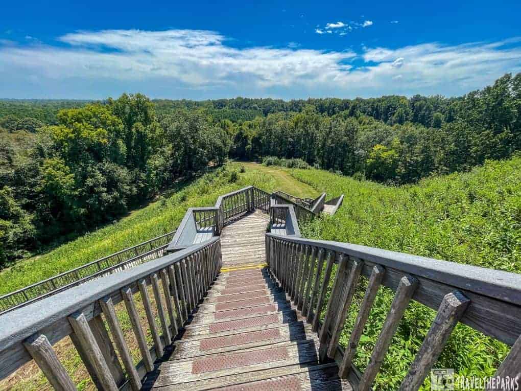
The Great Temple Mound was rather impressive, the largest on site. It stands approximately 55 feet in height with a base measuring 300 x 270 feet. This mound likely had wooden structures on top for used for religious ceremonies connected to the community’s spiritual beliefs. Some researchers believe that the mound also served as housing for the elite members of the community. A paved path led us to a steep set of stairs to climb to the top of the mound. Once at the top, we got surprising 360-degree panoramic views. To the east, stunning vistas overlook downtown Macon and the Ocmulgee River.

The Lesser Temple Mound, a slightly smaller structure, stands beside the Great Mound. Native American communities likely used this secondary mound for religious ceremonies, believing it housed ritual structures that reflected their spiritual beliefs and practices. In 1843, the railroad construction took a chunk of real estate from the lesser mound.

Funeral Mound: A Reflection of Ancient Traditions at Ocmulgee Mounds
This mound was primarily associated with burial practices and the reverence for ancestors. Based on archaeological findings, ancient people used a combination of earth and clay to construct this mound and performed at least 100 burials here. The mound once stood 25-feet tall, built with 7 distinct layers. Unfortunately, again, the construction of a railroad in the 1870s resulted in the partial excavation and destruction of the mound.

Explore the Cornfield Mound While Visiting Ocmulgee Mounds
Archeologists excavating the mound uncovered evidence of a past cornfield and maize cultivation, a dietary staple for many Native American communities. Beneath the mound, they found burned corn cobs and distinct rows from agricultural practices. Researchers believe the mound served a ceremonial purpose for the local population..

Hiking the Dunlap Mound Trail: Part of Our Ocmulgee Mounds Visit
Dunlap Mound trail offers a glimpse into the region’s Civil War history, leading visitors to one of the few remaining earthworks from that era in Macon. Southern soldiers constructed these fortifications after the Battle of Dunlap Hill on July 30, 1864, and then employed them in the Battle of Walnut Creek later that year. The trail bears the name of Samuel Dunlap, who acquired the land in 1856 to build his house and dairy farm, and the Dunlap House is still privately owned to this day.

A Quick Visit to McDougal Mound at Ocmulgee Mounds
This mound was named after the soldier who commanded Fort Hawkins in 1809, Captain Robert McDougal Mound. Legend claims he was buried in a small Indian mound near the old fort. However, when archaeologists excavated the mound in the 1930s, they found no human remains.

Final thoughts: A Guide to Visiting Ocmulgee Mounds National Historic Park
As we walked through this park, I couldn’t stop thinking about the people who lived here a long time ago. I asked myself these questions. What tools and resources were important for their survival? How did they build their homes? These mounds give us a peek into how people lived every day, helping us to imagine the struggles and adventures of the ancient people who lived here. If you are interested in learning more about our history, you must visit this park. Ocmulgee Mounds National Historical Park is indeed one of the most prominent when it comes to visitation. However, there are other notable mounds, such as Effigy Mounds National Monument and Etowah Indian Mounds State Historic Site (1000 BCE to 500 CE), Poverty Point Wold Heritage Site (1700 BCE to 1100 BCE), and Cahokia Mounds (600 CE to 1400 CE).
Have you been to Ocmulgee Mounds? What did you think of it? What did you do there? Do you want to go? Please share your thoughts in the comments below.


