When most people think of national parks in the United States, iconic names like Yellowstone, Grand Canyon, or Yosemite immediately come to mind. However, there are true gems waiting to be explored beyond the well-trodden paths of these popular destinations. One such hidden treasure is the often-overlooked North Unit of Theodore Roosevelt National Park in North Dakota. This isolated and enchanting part of the park has much to offer those willing to venture off the beaten path.
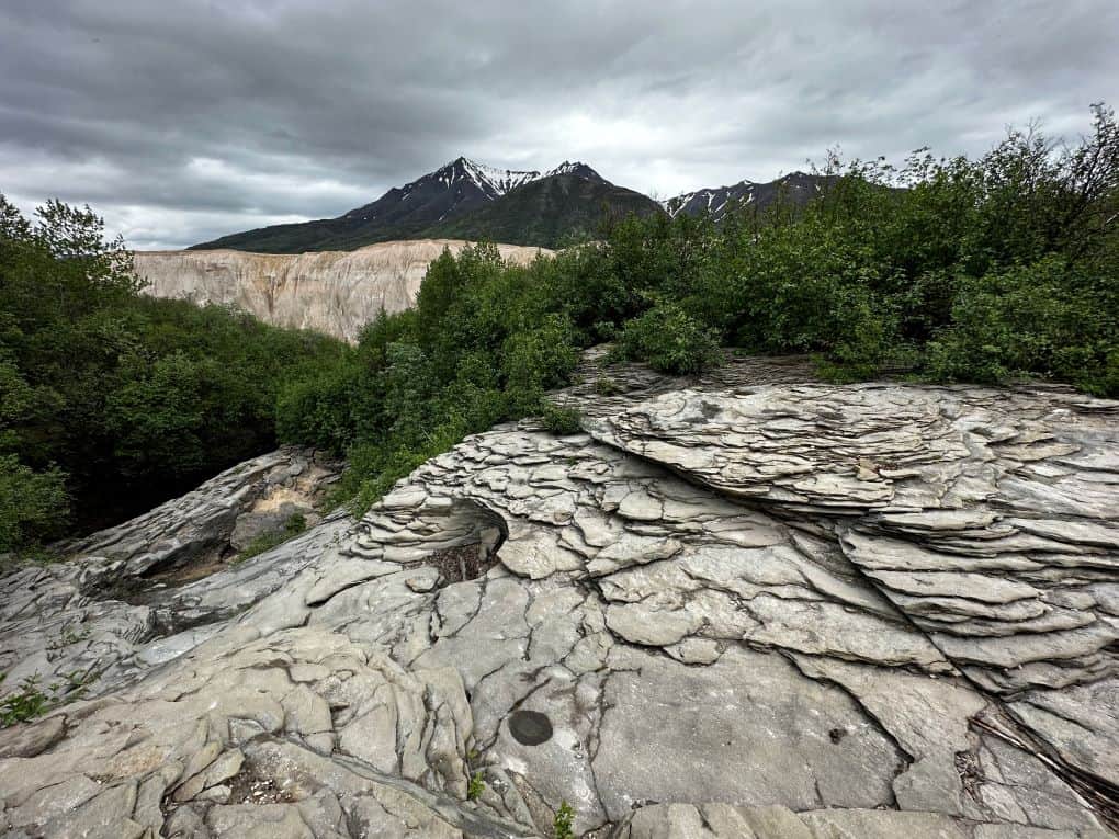
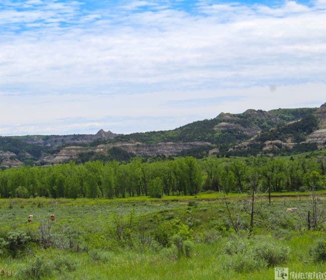
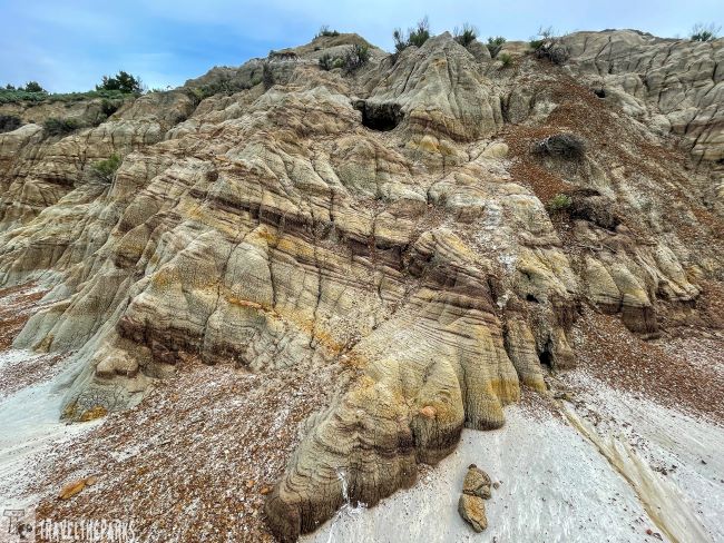
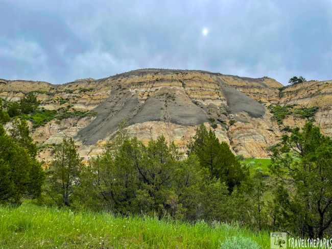
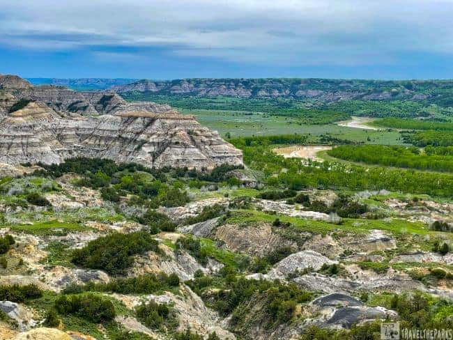
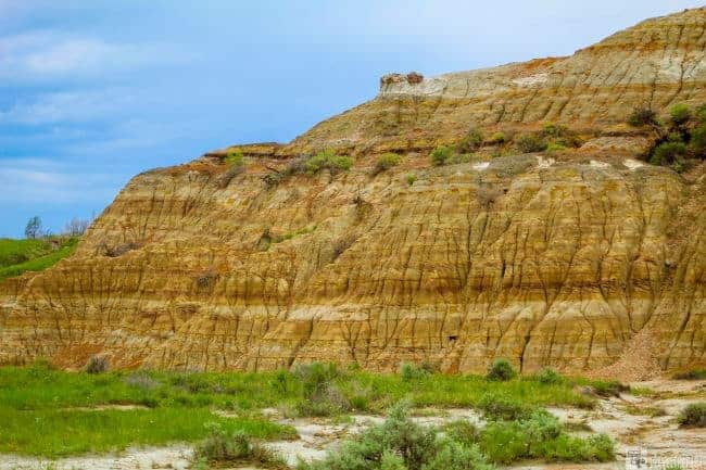
The North Unit is a section of Theodore Roosevelt National Park that is one of the more remote areas of the national park. I feel like we underestimated the North Unit. It was by far my favorite section for adventure in the park. The North unit’s geological features are more vividly colored, unlike the Badlands of South Dakota. This outlying section of the park has varied layers of rock, rolling, green prairie, and spectacular river vistas. Each trail seemed to showcase different geological aspects of the park.

This post may contain affiliate links, meaning if you purchase something through one of these links, we may earn a small commission at no extra cost to you! Read the full disclosure policy here.
Theodore Roosevelt himself once said, “I never would have been president if it had not been for my experiences in North Dakota.” His time in this region was instrumental in shaping his conservationist ideals and his vision for America’s national parks.

Table of Contents
How to Get to Theodore Roosevelt National Park-North Unit
From the north, the park entrance is 15 miles south of Watford City, North Dakota, off Highway 85. From the south, it is 50 miles north of Belfield, ND. Take U.S. Highway 85 north at Exit 42 off I-94 in Belfield, ND.
Theodore Roosevelt National Park is open 24 hours a day all year round. A NPS pass or entrance fee is required to access it; $30/vehicle, $25/motorcycle or $15/hiker, biker or horse (valid 7 days). Better yet, for $80, you can purchase an annual pass that will give you access to all 62 national parks and most of the additional national park units & forests.
Note: It is important to note that the North Unit operates on Central time, while the South Unit operates on Mountain time.

Know Before You Go: North Unit of Roosevelt National Park
- Park Hours & Fees: Open year-round, 24/7. Entrance fees apply — valid for both the North and South Units. Visitor Center is seasonal and limited in services.
- Services Are Limited: No gas, food, or lodging inside the North Unit. Closest full services are in Watford City. Bring water, snacks, and essentials.
- Pets are welcome in the North Unit, but with important restrictions: Allowed: In developed areas, campgrounds, parking areas, and along roadsides. Not Allowed: On hiking trails, in buildings, or in backcountry areas. Leash Required: Pets must be on a leash no longer than 6 feet at all times. Clean Up: You must clean up after your pet—pack out all waste.
- Best Time to Visit the North Unit: Late Spring to Early Fall (May–October) is the ideal window: June–September offers warm temperatures, green landscapes, and active wildlife. Fall (September–early October) brings vibrant colors and cooler temps — a peaceful, picturesque time with fewer crowds. Summer (July–August) can get hot but is best for full road/trail access. Winter (November–March) is beautiful but harsh — limited services, snow, and potential road closures make access trickier.
North or South Unit? Which is Best?
Why not do both? They subdivided this park into three sections: the North Unit, the South Unit, and the isolated Elkhorn Ranch Unit. In the North Unit, the badlands are more rugged, with panoramic views of the Little Missouri River from the mesa tops, while in the South Unit, the badlands are more spread out over the grasslands of North Dakota. The South Unit and Medora are the only two areas most people see when they visit TRNP.

#1-First Stop is the Visitor Center
Near the entrance is the north unit lone visitor center, housed in a small trailer. Restrooms are in the adjacent trailer. This is always our first stop when touring any park. Here we can always get weather and road condition updates, secure a backcountry permit, receive our passport stamps at the bookstore, or watch the park film before looking at the exhibits. Park maps are available for download here.

#2-Drive the Remote Scenic Road through the North Unit of Roosevelt National Park
The scenic 14-mile out and back drive offers several places to pull over or scenic lookouts. The rugged splendor of the badlands will leave you enchanted.
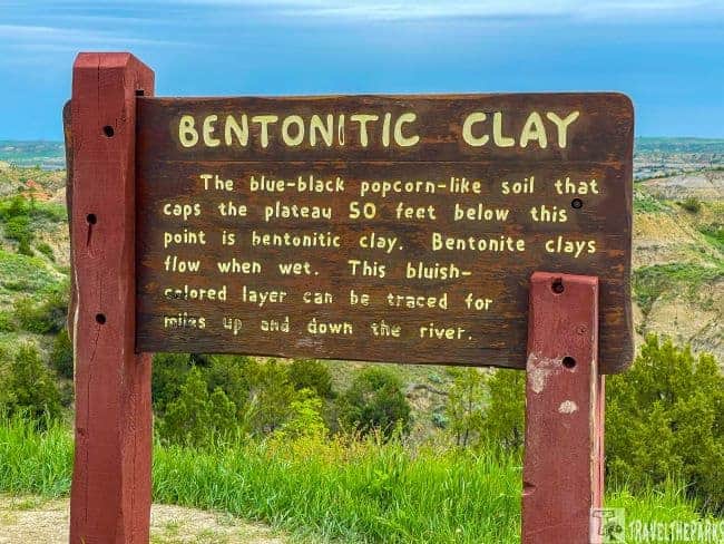
The overlooks include Longhorn Pullout, Slump Block Pullout, Cannonball Concretions, Long X Trail, Caprock Coulee, Riverbend, bentonitic clay, Man and Grass, Edge of Glacier and the Oxbow Overlook.


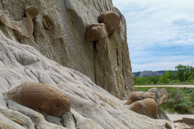
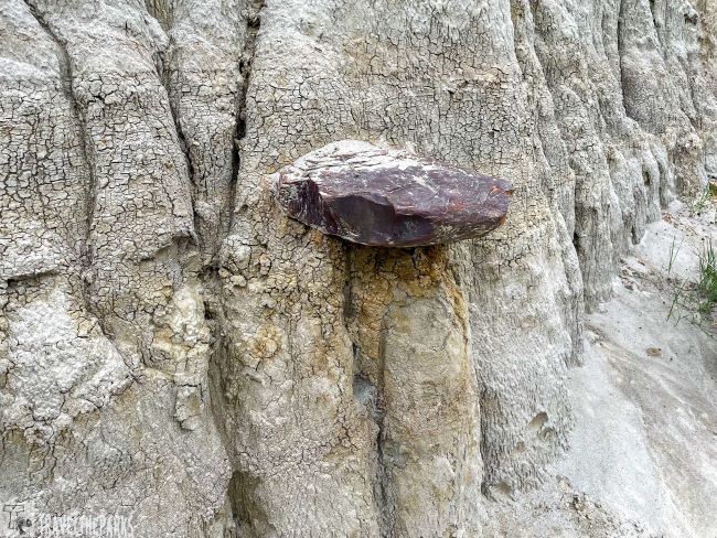
#3-Cannonball Concretions Pullout
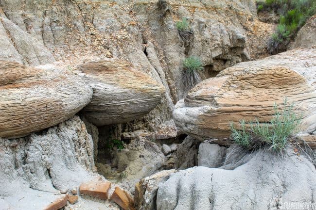
This may be the extraordinary geological formation that I’ve ever seen. These strange spherical boulders look like giant cannonballs. Thus the name. Some lie amongst the sagebrush flats, others are protruding from the eroding cliffs. Perfectly smooth and round.
When I taught earth science, my students learned about river cementation, which is how I thought these got here. However, they are formed when mineral-rich waters deposit minerals into voids or gaps in the porous sediment layers of the badlands, creating these otherworldly oddities. It is these minerals that act as a kind of glue to hold these sediments together, often forming around a core of rock.
Walking around and through the ravine canyon, we saw vertical pipe caverns created by the erosion of the softer rock within the butte. Caprock on the top shields the cave. It was interesting, to say the least.
#4-Riverbend Overlook-The View that Launched a Park
There are many incredible overlooks in Theodore Roosevelt National Park, but this is one of the most impressive. No where else in the park are the views more sensational than here at the River Bend Overlook. Among the units in the park, the North Unit was my favorite.

Construction of the shelter that now dominates this point above the river began in 1937, shortly before this overlook became one of the top attractions on the scenic byway or even a national park. An easy walk from the parking lot, the shelter is built from natural materials such as the rocks that were quarried in the park.
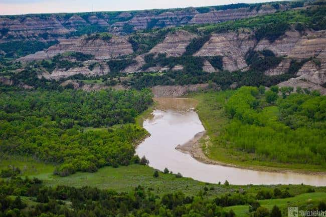
It was simply breathtaking to see the Badland buttes and Little Missouri valley from this perspective. Despite being beautiful, the pictures cannot convey the full effect of the experience. The flood plain of the Little Missouri River was lush with green vegetation and wildflowers. The river brown choked with mud from the spring rains. The hues of the multicolored layers against the green valley were beautiful. Even the overcast skies could not hide their vibrant colors.
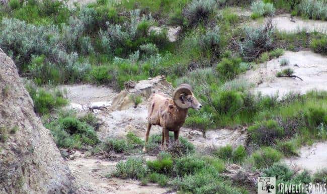
We looked for bighorn sheep on the steep slopes. Luckily, two were resting at the base of the cliff not to distance from the shelter. Clambering down the rock face, I got a few photographs. This was a highlight for us, as we have not seen bighorn rams on any of our trips to the parks.
#5-End of the Road-Oxbow Overlook
Climbing the slope to the top, you get sweeping panoramic 180° views of the Little Missouri. This is an excellent place to see the sunrise or the sunset. The wide open vistas, rich colored canyon walls are stunning in either direction. It puts this place in perspective. I definitely felt small. They named the bend for the meander in the river. Natural forces of nature, such as flood cycles of the Missouri River, create channels that are constantly shifting. The river has carved the canyon over time as it gains and loses speed. Remarkably, during the last ice age, glaciers blocked the Little Missouri from flowing north to Hudson Bay before changing its course here and turning hard east.
Oxbow Overlook is the trailhead for the 18-mile Achenbach Trail. To get to the intersection of the Achenbach Trail, we followed the Sperati Point trail for 1.2 miles. Not much shade on either trail, so bring plenty of water. There are restroom porta potties at the parking lot.

Hiking Trails in the North Unit of Theodore Roosevelt National Park
The Northern Unit of Theodore Roosevelt National Park is where you will find some of the best hiking trails. Dogs are not allowed on any of the trails in the park.
What should we bring? Remember, a good pair of sunglasses, sunscreen, towel, ball cap or wide-brimmed hat, and a light loose-fitting long-sleeved shirt for sun protection while on the trail. If you plan to walk the trails, bring bug spray for the biting insects and ticks. Some trails, poison ivy is widespread and always be aware that prairie rattlesnakes call the park home.
Remember: Bring at least one gallon of water with you, as there is no filterable water along the trails.
#6-Our Favorite North Unit Hike In TRNP- Deserted Caprock Coulee Loop Trail
By far, the best hiking trail was the Caprock Coulee. This trail has an elevation gain of almost 600 feet over its 4.4 miles. They rate this trail as moderate to strenuous. The path takes you to the top of grassy buttes, and through rugged ravines providing incredible views of the North Dakota badlands’ geological formations.
The trail gets its name from two different geological features. Caprock typically has a thick layer of sedimentary rock, typically sandstone or volcanic ash, underneath the more stable limestone or basalt. The softer layers erode faster than the harder top layer. In Bryce Canyon National Park they are called, “Hoodoos.”

Coulee refers to steep ravines that can be wet during the summer and dry during the winter. They derive it from the Canadian French word coulée, which comes from the French word couler, meaning “to flow.”
Petrified wood dominates the slopes of the canyon wall. Large chunks of petrified wood protruded from the eroded cliffs. he ancient remnants of towering trees, now fossilized into colorful stone, create a striking contrast against the rugged landscape.
Note: We advise caution in the spring when the trail gets muddy, and the clay is very slippery. Wear good hiking boots and long pants to protect against ticks in the long grasses. We recommend trekking poles for steep grades.

Quiet Yet Educational Caprock-Coulee Nature trail
It is best to start by hiking the Caprock-Coulee Interpretive Nature trail counterclockwise, beginning with the 0.75-mile self-guided nature trail. Starting from the trailhead, take the left fork as it winds through the coulee, identifying 21 stopping points that illustrate the flora, fauna, or geology of the park (the right fork is the Buckhorn trail). Pick up a trail brochure (download the NPS app) stop at each numbered trail post and read the information. It seemed like every twist and turn through the canyon we encountered a rabbit. Maybe it was the heavy rains from the previous day, but they were everywhere. We came across no other hikers. It felt deserted, like we had the trail all to ourselves.

Once you reach the end of the nature trail, the landscape changes as you climb out of the coulee to the top of the butte. Most of the trail continues through lush green grassland prairie. Usually, you will find bison grazing on the trail. Dodging bison patties is a given. Once you reach the road at the river bend parking lot, the trail follows the scenic road over the tableland.

Solitary Trail Over the High Ridge
The River Bend Overlook, with its CCC-built shelter overlooking the river, provides 180-degree panoramic views of the Little Missouri Valley. The trail continues along a high narrow ridge before reaching a juniper forest completing the loop. Just FYI, if you have a fear of heights, this end portion may be problematic. I don’t like heights but had no issue completing this section of trail.

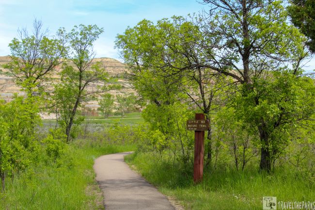
#7-Hidden in Juniper Campground the Little Mo Trail
Pull over at Little Mo Nature Trail, where you’ll find an easy hike with 1.1 miles of unpaved trail and 0.7 miles of ADA-accessible paved trail. Find out more about this river bottom habitat by picking up a self-guided trail brochure at the trailhead or download the NPS app ahead of your hike. I previously downloaded the brochure onto my phone, so we could stop at each numbered post to read through the information.
Just as we were getting started along the trail, a rather large snake bolted off the trail, caught me of guard, about scared me to death. Later, we saw a smaller snake on the edge of the creek that quickly darted into the water. This trail through the bottomland scrub is a perfect home to a diverse bird population. If you are an avid birdwatcher, this trail is ideal for bird spotting. High above us we spotted a soring Golden Eagle. Multiple other species frequent the scrub such as Lazuli Bunting, Western Meadowlark, Spotted Towhee and Mountain Bluebirds.

As we approached the river, the wildflowers became more spectacular. Riverbanks were lined with yellow Golden Peas. The vibrant colors contrast starkly with the multihued canyon walls that rise above the Missouri. During the peak wildflower season, the park usually has blooms that last from mid-June into mid-August.
#8-Paradise on the Secluded Buckhorn Trail
This 11.5 -mile trail is moderate to strenuous 6-8 hour hike. The trailhead begins across from the Juniper Campground near the Cannonball Concretions pullout. Although the cannonballs are unique to the north unit, there are other features along the trail that are just as magnificent. The dramatic landscape showcases the multicolored layers of the badlands hills. Prairie dog towns scattered along the trail. These little critters are so entertaining! In the spring, the smaller offspring are just venturing out of the burrows to explore. I could spend hours watching them. Alas, due to time constraints, we had to move on. We encountered only a few bison today, mostly on open prairie. Luckily, none are blocking the trail. Do not trifle with bison, they can be dangerous. Give them a wide berth.

The fairly well-marked trail is easy to follow. Occasional section of the trail can be very mucky from the early spring rains. Our hiking boots gave us good traction and kept our feet dry in the areas where we had to navigate small streams. Trekking poles and long pants were essential for this trail.

#9-View Diverse Wildlife in the North Unit of TRNP
The north unit has 82 percent of the park designated as wilderness. The scenic road only covers a small area. However, finding wildlife is relatively easy. The secluded north unit is an excellent place for seeing bison, bighorn sheep, white-tailed or mule deer, prairie dogs, and bald or golden eagles. Since there are fewer visitors, the wildlife is abundant. On many of the trails, we encountered bison, turkey, rabbits, bighorn sheep and even a golden eagle.
PRO Tip: Approaching bison threatens them and they may respond by bluff charging, head bobbing, pawing, bellowing, or snorting. These are warning signs you are too close and that a charge is imminent. Do not stand your ground. Immediately walk or run away from the animal.

Tips & Tricks to Know Before You Go to TRNP
- Always practice Leave No Trace ethics on your adventures and follow local regulations. Please explore responsibly!
- Cell service is not always reliable. Remember to download GPS or AllTrails apps prior to arriving at the park.
- You may walk your pet on sidewalks, roads, parking lots, and campgrounds as long as it is leashed and accompanied at all times. It is your responsibility to clean up after your pet. Visitors may not bring pets into buildings, onto trails, or into the backcountry.

Final Thought on the Isolated North Unit-Teddy Roosevelt National Park
There are many things a picture cannot depict – the scent of grass, the morning fog, the wind, the solitude of this vast wilderness. It is nearly impossible to convey in a picture the feeling of looking out over this expanse from the top of the overlook. Theodore Roosevelt National Park, including the North Unit, plays a vital role in preserving the natural beauty of the Badlands and the ecosystem it supports. The park is not only a testament to the conservation efforts inspired by President Roosevelt, but also an opportunity for visitors to connect with the untamed wilderness of the American West.
We were captivated our entire time in the Isolated North Unit of Theodore Roosevelt National Park. It will always hold a special place in my heart. It is one of our favorites.
Have you been to TRNP the North Unit? What was your favorite thing to do? Tell us about it in the comments below!