
Our 20-day Texas and New Mexico road trip began on a cold, overcast day. During our adventure, we travelled through some of the most beautiful landscapes in Texas and New Mexico. We got to see so many extremes, from the rugged mountains of Big Bend to the surreal landscape of White Sands. Along the way, we stopped to explore 5 national parks and a few state parks. Take the road less traveled and hike these fascinating places.
This post may contain affiliate links, meaning if you purchase something through one of these links, we may earn a small commission at no extra cost to you! Read the full disclosure policy here.

Table of Contents
This Epic Road Trip Itinerary: Journey Through Five Spectacular Southwestern National Parks
Our trip started in Florida, then we hit the Gulf Islands National Seashore and crossed Alabama, Mississippi, and Louisiana before entering Texas. We made a brief stop in Houston to visit family. From Houston, we looped through San Antonio, Amistad, Big Bend, Fort Davis, Guadalupe Mountains, Carlsbad Caverns, and White Sands. Oh yeah, just for fun, we added Hot Springs National Park in Arkansas on our way home. Yes, this trip covered 4200 miles over 20 days and lots of driving, but it was worth the experience. Just the two of us and our dog, Sage.

If RVing isn’t for you, you can fly into El Paso, Texas, rent a car, and drive. There’s only a couple of hours’ detour to Hot Springs National Park, so we added it. Travelling during the Christmas holiday, the weather is cooler in many of the desert parks. Winter is an ideal time to do this itinerary.
- Big Bend National Park
- Guadalupe Mountain National Park
- Carlsbad Caverns National Park.
- White Sands National Park.
- Hot Springs National Park

Sun, Sand, and History: Exploring Fort Pickens Gulf Island National Seashore
Our first stop was the Gulf Islands National Seashore, a veritable treasure. Even though it was blustery and cool, we didn’t let it stop us. The two days we were here were great. Taking the trailer into Fort Pickens Campground, Loop A, we set up camp before going for a walk on the beach. There were rough waves from an offshore storm, but they were still mesmerizing. As this is a pretty dog-friendly park, we took Sage out on the trails the first day. Birds are everywhere, but other animals are scarce. There isn’t a dog beach in the park, but Pensacola has one. I laughed, watching Sage because he’d never seen waves or been to a sandy beach before.
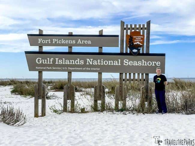
Note: Fort Pickens Campground is well-maintained and offers a variety of campsites to suit all needs, from tent-only sites to RV hookups. There are also restrooms, showers, and a dump station available.
Spending Time on a Self-Guided Tour of Fort Pickens
After breakfast, we spent the whole day at Fort Pickens. This historic fort is a place where you will learn a great deal. Do a self-guided hike or ranger-led tour to get the most out of this fort. The massive installation has a few masonry batteries scattered around. Make sure you explore the Discovery Center, the batteries, and other buildings. You can also hike around the beach dunes and enjoy the remarkable views of Pensacola Bay.
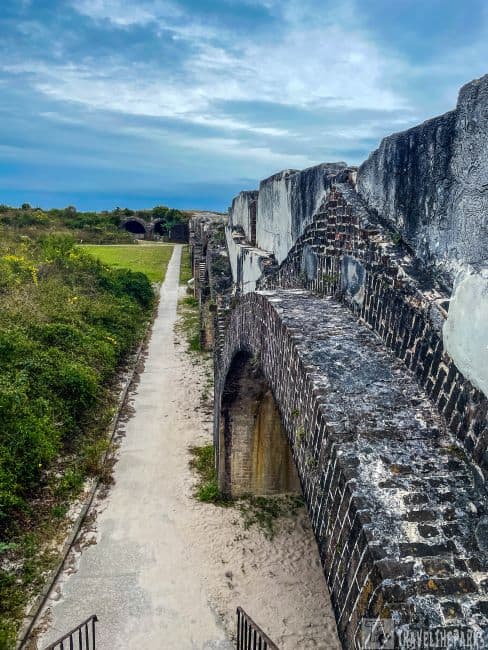
One of the most interesting discoveries we read about is that this fort was a prison during the Civil War for Apache and Confederate renegades. It was here that Geronimo was once imprisoned. While touring the fort, I speculated, what if the walls could talk? They’d tell stories. Storms have battered these walls, and trials and tribulations have tested them. Yet the fort still stands as a testament to the resilience of the human spirit. It is a reminder of the many lives that have been lost and the horrors of war. It is a reminder of the importance of preserving our history and respecting our past.

Saying Goodbye to Fort Pickens
Dinner at Peg Leg Pete’s followed the sunset. Finishing our day with drinks and fresh seafood was ideal. Beach lovers will love the Gulf Islands National Seashore’s 160-mile stretch of beaches and islands. The next morning, we started the day early by walking Sage through Blackbird Marsh. Today we are moving on to Louisiana. We said goodbye to Fort Pickens and hit the road. We’re excited to explore a new state and make some memories.

Texas and New Mexico Road Trip: Bayou Bliss Camping Adventures in Butte La Rose
The drive to Butte La Rose in the bayou was mostly views from I-10. Passing through Mobile, we could see the USS Alabama Battleship Memorial Park. We couldn’t stop; we had to follow our itinerary. That’s the problem with having a schedule.

Visiting Butte La Rose is like driving through a Louisiana postcard. We followed the paved road paralleling the levee. I felt we were getting an authentic Cajun experience as we descended into the bayou. I was beginning to get swamp vibes when we turned onto the winding road to the campground. At Uncle Buck’s Campground ($10/night), you’ll find full hookups, picnic areas, a boat ramp, a new playground, and a fire pit for a bonfire. The proximity to the bayou is one of the biggest perks of camping in Butte La Rose. Your campsite is the perfect launch point for kayaks and canoes. It was magical to walk Sage in the morning mists and see the reflections on the water. It was tranquil listening to birdsong as the morning sun rose, waking over the river.


Journey to Texas and New Mexico: Atchafalaya National Wildlife Refuge
Packing up camp and heading back toward the highway, we made a brief stop at the Atchafalaya Wildlife Refuge Welcome Center. You can enjoy free coffee, restrooms, trails, and picnic spots at the center. Here you can pick up maps, information about wildlife, educational materials, and details about any ongoing programs or events. The lobby was beautifully decorated for Christmas. A feeling of warmth and welcome washed over me. If you need a free quick stop for the night, the parking lot here accommodates any-sized rig. Outside is a memorial dedicated to the 82nd Airborne Division. It celebrates those Cajuns who sacrificed during the D-Day invasion of Normandy in World War 2. Continuing on I-10 East on the 18.2-mile Atchafalaya Basin Bridge; you get wonderful overhead views of the bayou. It really is a spectacular sight

Exploring San Antonio’s Historic Treasures: Things to Do in San Antonio
After spending a few days visiting family in Houston, Texas, we made the short, three-hour ride to San Antonio. Just outside of town, alongside I30, we spent a night in the Stone Creek RV Park. With full hookups, laundry and shower facilities, a dog park, and a recreation room, this park has it all near all the downtown San Antonio activities.

Exploring the Lone Star State: The Rich Tapestry of the Alamo
On our first day, we checked out The Alamo and the Riverwalk. In our opinion, it’s an iconic building synonymous with Texas. An important part of our story it’s an absolute must-see. They built the Alamo in 1718 and originally named it Mission San Antonio de Valero. The Alamo served as home to missionaries and their indigenous followers for nearly 70 years.
Note: Timed-entry reservations are required for the Alamo Chapel. They are free to book online. Park in a lot a few blocks from the venue to save a few bucks. Both the Remember the Alamo Guided Tour and Phil Collins’ collection of artwork and memorabilia are an additional charge.

Immersive Reflections: The Alamo Chapel
Self-guided tours of the chapel, long barracks, palisade, and courtyard were fun and worth the time. We began our tour, stepping through the wooden doors and entering the chapel first. Although the structure has been rebuilt, restored, and reinterpreted over time, it is rather small footprint with only 10% of the original remaining, sandwiched in by downtown San Antonio. The chapel does a good job of covering the history of Texas and Mexico. The sacristy room is a place for critical reflection, a memorial to the Alamo defenders. They played a crucial role in the Battle of the Alamo in 1836. We took a moment to stand in the very spot where Davy Crockett, Jim Bowie, and William Travis made their legendary last stand. They, along with a small force of around 180 to 250 men, held the Alamo.

A Stroll Through the Epic Alamo Plaza
It surprised me to see musket holes and scorch marks remaining in the walls. For 13 days, the vastly outnumbered Texans endured a siege by Santa Anna’s army of 4,000 soldiers. I cannot imagine all those men, women, and children outnumbered by the Mexican forces under bombardment. Only a few survived the last assault on March 6. The Alamo isn’t just about the past. It’s a living testament to the power of community. It represents the act of standing up for what you believe in, even when the odds are stacked against you. As we leave, we carry that spirit with us. Remember the Alamo and remember why we Texans hold it dear. It really is a “bucket list” destination.

The long barracks is the oldest building on the Alamo grounds, dating back to the 1720s. Exhibits inside provide a timeline of the Alamo as well as showcasing the daily lives of the Alamo’s settlers. In the living history encampment, historians dressed in period attire let you travel back in time to the 1830s. It was fun putting myself in their shoes. The encampment is a great experience for kids, especially the rifle and cannon demos.

A Leisurely Stroll Along San Antonio’s Enchanting Riverwalk
Afterwards, it was time to head towards the meandering River Walk. Even prettier than we’d imagined, it was lit up with twinkling lights and decorations, creating festive holiday vibes. This vibrant urban oasis, from the iconic arched bridges to the charming riverside restaurants. Every step was a delight. Charming riverboats offer guided tours with insights into the history and culture of San Antonio. Joseph’s ice cream gave us a chance to sample a taste of San Antonio’s magic.

Pedaling Through History: Biking the San Antonio Missions Trail
I highly recommend seeing the National Park Missions along the River Walk Trail. Renting an e-bike is the best way to see the San Antonio Missions National Historic Park. There are several bike rental shops near the Alamo. The 9-mile trail winds its way along the San Antonio River, past five of San Antonio’s Spanish colonial missions. Mission Concepcion (1755) is one of the oldest unrestored stone churches in America. The Spanish colonial architecture is unmistakable. We listened to the free cellphone tour to learn about the frescos.

Next on our biking tour was Mission San José (1719) referred to as the “Queen of the Missions.” This is where we took sometime to see the visitor center and get our passport stamps. This mission is the largest working agricultural community. It features a gristmill, a granary, and a rose garden. The grandeur of the Rose Window is one of the artistic influences.

Mission San Juan (1716) and Mission Espada are less crowded but equally captivating. Mission San Juan Capistrano features a demonstration farm. We admired the Spanish colonial style, with thick stone walls, arched doorways, and a bell tower. Our last stop was Mission Espada (1690). It is renowned for its well-preserved acequia (irrigation canal) and remarkable aqueduct system (1745).

Nature’s Oasis, Amistad National Recreation Area, on our Texas and New Mexico Road Trip
Our visit to the park centered on the Amistad Reservoir on the Rio Grande River was short. With over 58,000 acres, the recreation area offers fishing, boating, hiking, camping, and wildlife watching. As we’ve seen on the Bassmaster Tour, Amistad Reservoir has excellent largemouth bass fishing. It’s produced monster fish for many anglers.

Interesting fact: one of the largest largemouth bass ever caught in Texas came from the reservoir in 1989. The fish weighed in at 18.18 pounds and measured 25.5 inches in length. This catch made headlines at the time, and the record remains.
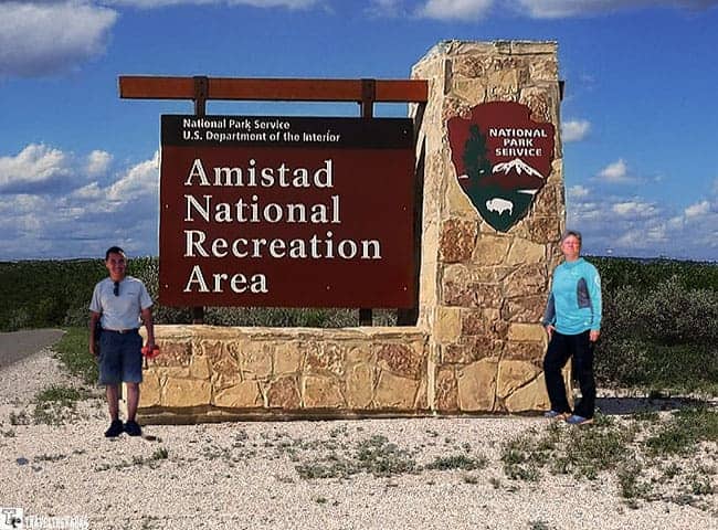
In the park, there are several hiking trails that give you a magnificent view of the reservoir. You’ll find trails for all levels, from easy nature walks to more challenging hikes. Several campgrounds are available for visitors to stay overnight, including developed sites and backcountry sites. As we moved on, we stopped at Seminole Canyon State Park for the night.

Discovering Southwestern Ancient Wonders at Seminole Canyon State Park
Whether you’re looking for rugged landscapes, ancient history, or outdoor adventure, Seminole Canyon State Park has it all. As soon as we set up camp, we couldn’t wait to find out more about this place. Take the Fate Bell Shelter walk if you have a chance. There is only one way to see the pictographs. You must take a guided tour led by a knowledgeable park ranger. The cost is $8 per person. Each tour departs twice daily, at 10 a.m. and 3 p.m. Prior to the tour, we spent time looking over the exhibits. Beginning with dioramas on the early inhabitants, the timeline progresses through to the building of the Pacific Railroad.

Outside the visitor center, our experienced guide, Betsy, met us at 3 pm sharp. She welcomed us, setting the stage for a captivating exploration of the artistry that has endured for over 4,000 years. The highlight of our tour is undoubtedly the ancient pictographs that adorn the walls of Fate Bell Shelter. Beginning at the Windmill Nature Trailhead, we followed the switchbacks, passing the Maker of Peace of an Indian shaman.
TIP: The Texas sun can be relentless. Bring plenty of water, wear a hat, and apply sunscreen to stay comfortable during your explorations.

The Ancient Petroglyphs of Fate Bell Shelter
Reaching the top of the canyon, the group descended the steep rock stairs to the canyon floor. We found ourselves surrounded by towering canyon walls carved by the forces of time. It definitely creates a dramatic backdrop against the clear Texas sky. These ancient paintings, colored with vibrant red, yellow, and black hues, depict scenes of hunting, rituals, and daily life. In the cool recess of the alcove, we admired ancient artwork. As we stand in awe, our guide shares insights into the meanings behind the pictographs. These are thought to be the oldest pictographs in North America. Come alive.

The spread-out campsites are on a rise overlooking sagebrush vegetation. They are level, well-maintained and have water & electricity. The sunset was absolutely amazing. I wish we had more than one night here.
In the early morning, we took Sage along the 5-mile rim trail to Panther Cave overlooking the Pecos River. Unfortunately, the fog completely obscured the view, so we took no pictures. It was surreal walking among the cactus and sagebrush, spotting the occasional cottontail. Returning to the campground, we broke up camp, preparing for the drive to Big Bend.
Note: Hiking boots and trekking poles helped with traction on these trails.

NOTE: Purchasing the Annual Pass ($80) is worth it if you plan on visiting more than one national park. More than 2,000 federal recreation sites are included in the America the Beautiful National Park and Federal Recreational Lands Pass.
Deserts, Mountains and Rivers Flow Wild in Big Bend National Park
Big Bend National Park is quite immense. The name itself conjures images of the vast, untamed wilderness, and the reality does not disappoint. It was where we experienced some of the most dramatic landscapes on our road trip. Taking two days, we did lots of hiking trails, soaked our feet in the hot springs, and took a scenic drive along the Ross Maxwell Scenic Drive.

Note: Pack a good pair of binoculars. The birdwatching opportunities are off the charts.
The Chihuahuan Desert, the park’s heartland, is a world unto itself. Big Bend’s remoteness is part of its appeal. The best time to visit Big Bend is in the spring, from mid-March to mid-May. It is also excellent in the fall months of October-November when the temperatures are mild and the crowds are smaller. The Christmas break seemed ideal, but the park wasn’t so secluded.

Masters of the Deep at the Fossil Discovery Exhibit
We entered the park via Highway 385, Persimmon Gap Visitor Center. It’s rare to see a restroom on these long drives, so we just stopped quickly. We snapped our photo by the park sign before going to Rio Grande Village.

You’ve got to see the Fossil Discovery Exhibit. The building was designed to blend in with its natural surroundings. It’s an open-air, self-guided interpretive exhibit with fossils from 130 million years of geological history. Apparently, this part of Texas was a vast inland sea during the prehistoric Late Cretaceous period. We saw fossilized bones, teeth, and tracks from various marine reptiles. Fearsome reptiles like the mosasaurs — large serpentine lizards up to 60 feet long, powered by a powerful tail and paddle-like limbs, roamed the ocean. King of the skies, the pterosaur (Quetzalcoatlus northropi) with a 35-foot wingspan. It was hard to imagine a creature with the wingspan of a small airplane flying overhead.
This is a great stop for kids to experience, and one that we highly recommend. The short trail leads up a hill for panoramic views of the valley. A small playground and picnic area are here as well.

Panther Junction Visitor Center, Big Bend National Park: Chisos Basin
It is open from 8:30 AM to 5:00 PM every day. It’s a great place to start your visit to Big Bend National Park. There is a park ranger information station with a theater, a museum, a nice bookstore and gift shop, and a nature trail. Inside there are impressive exhibits about the history, geology, plants and animals. If you are looking for free Wi-Fi, most visitor centers have it available. After getting our maps and information, we enjoyed exploring the walking trail and learning about the native species within the park.

As we drove towards Rio Grande Village from Panther Junction, the Chiso Mountains rise dramatically from the desert floor. The light constantly shifts throughout the day. I could not stop taking photos of them. Opting to keep moving, we made it to Rio Grande Village Campground in time to watch the sunset. The campground is basically an asphalt parking area. However, it is the only campground in the park with electrical power. There are a variety of camping options available in the park, ranging from developed campgrounds to remote backcountry sites.

A Welcome Chihuahuan Desert Reprise: Rio Grande Village
There are plenty of things to see at Rio Grande Village. The Visitor Center has good exhibits, soak in the hot springs or, if you can spare the time, take a day trip to the charming Mexican town of Boquillas del Carmen. You can cross the border by boat or walk, depending on the river level. From there, you ride a burro or take a taxi to the town where you can enjoy shopping, dining, and sightseeing. Visitors must return to the Boquillas Crossing checkpoint by 5pm.

Don’t miss the Hot Springs Historic District. The dirt road can be pretty sketchy, so a high-clearance vehicle is best. There is little wiggle room on the road. We lucked out, and the ranger gave us the last parking spot in the lot. This trail is a 1.5-mile loop. On the way to the thermal hot springs, you can see the well-preserved ruins of a resort hotel, post office, and petroglyphs. The Langford Hot Springs lay alongside the Rio Grande River. Known for their therapeutic properties, they are a great place to soak your feet.
Note: Valid passports required for US and Canadian citizens. While safe, exercise caution and common sense. Stick to well-lit areas and authorized tours, and stay informed about border crossing regulations.

Add A Day in the Chisos Basin on Your Ultimate Southwest Road Trip Itinerary
Leaving the trailer at Rio Grande Village, we got an early start. Starting your day early is best to make the most of your time in the Chisos Basin. Taking the main road, we turned onto Chisos Basin Road (6-miles). The drive to the Chisos Basin from Rio Grande Village takes about 45-minutes. Arriving early, we checked in with the rangers at the visitor center for trail updates. The exhibits are interesting and worth a look. We did the 0.3 mile Window View Trail first.
NOTE: Chisos Basin parking will fill quickly during the winter months and on holidays. During these times, the rangers will manage the number of visitors. It is not advisable to take a travel trailer or RV as the road into the Chisos Basin has a steep descent and hairpin turns.
We were bound and determined to hike both the “Window” and the Lost Mine Trail (4.8-mile round trip). First up was the 5.5 mile “Window” trail. Once we reached the end, I could not believe the breathtaking “Window” view that framed the desert below. It was so crowded, but taking the time to do this trail was so worth it. The same is true of the Lost Mine, very crowded on this Christmas Eve. No doubt you will enjoy sweeping vistas of the Chiso Basin, Casa Grande Peak, Pine Canyon, and the surrounding desert all the way to the Sierra del Carmen.

Texas and New Mexico Road Trip: Ross Maxwell Scenic Drive in Big Bend
This legendary scenic drive snakes through the parched desert scenery, ending at Santa Elena Canyon. The Ross Maxwell Scenic Drive is a particularly beautiful drive that takes you past some of the park’s most stunning scenery. We started our day bright and early, making a brief stop for gas at the Panther Junction Visitor Center.

The first stop was the Sam Nail Ranch. It’s a short 0.5-mile trail. You can see the ruins of the Nail family’s adobe ranch house, built in the early 1900s. Other notable stops include the Lower Burro Mesa Pouroff, taking the short hike. This trail led us to a hidden box canyon, where a dry waterfall cascaded down the colorful cliffs. The Homer Wilson Blue Creek Ranch Trail is a 0.5 mile out and back trail where the remnants of a once-thriving ranching operation can be viewed. The crown jewel is the hike in Santa Elena Canyon.

The Enchanting Southwestern US Beauty of Santa Elena Canyon
The canyon is the signature for most visitors. The dramatic gorge carved by the Rio Grande River’s sustained flow is a moderate, 1.7 mile, round-trip hike. Luckily, we found a parking spot for the truck and trailer, as this lot fills quickly. It was a chilly morning, so we left Sage in the trailer, as no dogs were allowed on the trails in Big Bend. Following the trail crossing Terlingua Creek, we climbed the paved switchbacks. I was a little winded, but stopped to appreciate the scale and beauty of this natural wonder. The expansive view of these sheer canyon walls rising 1500 feet above you is mesmerizing. Continuing on the trail, we walked down a path leading towards a wild cane patch growing on the riverbank. Eventually, the walls limit going any further.
If you plan to walk in the river, water shoes or sandals would be good to have; otherwise, you will have soaking wet hiking boots. A trekking stick would be ideal on the slippery rocks. The water is way too cold today, so we forgo the walk to the pebble sandbar.

Terlingua: A Chihuahuan Desert Oasis
The Castolon Visitor Center is open daily during the winter months. It has a ranger station, restrooms, exhibits, and houses the Big Bend Natural History Association Bookstore. Currently, the Garlick House is being used as a temporary visitor center because of ongoing renovations. Visitors can tour the Magdalena House and the Officer’s Quarters. We had to retrace our steps to get to our next destination, Terlingua.

Exiting the park via the Maverick Ranch entrance, we camped at Paisano Village RV Park in Terlingua. Miners founded the ghost town in the late 1800s when mercury mining began. The name of this town comes from the Spanish word for “three tongues,” referring to the three prongs of the Terlingua Creek. This campground is a gravel lot, but it was quiet with really clean restrooms and a bathhouse. Sufficient daylight allowed us to tour the Terlingua ghost town on our own before we had dinner at DB’s Rustic Iron BBQ.
Be sure to bring plenty of water and sunscreen, as the desert heat can be intense. Don’t forget to pack your binoculars and camera – Big Bend is a treasure trove for wildlife and landscape photography.

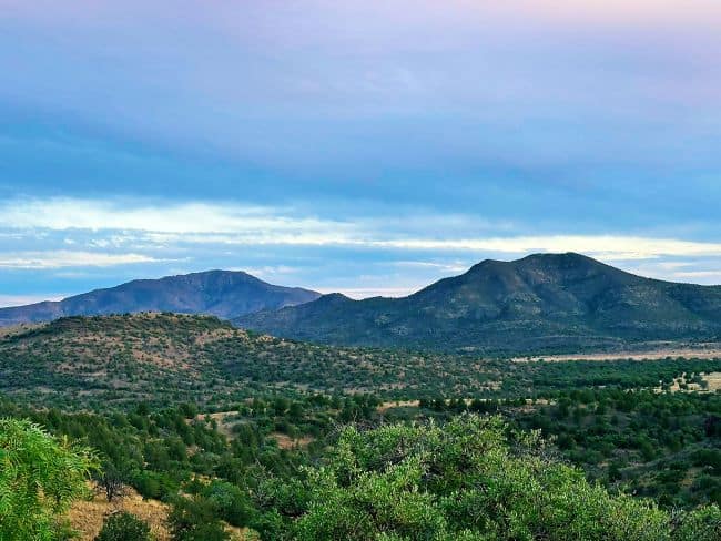
Fort Davis Historic Site: A Window into the Past in West Texas
Leaving Terlingua, we headed north to Guadalupe Mountains National Park. We made a few detours to see Fort Davis National Historic Monument to learn what role the fort played in the settlement of Texas. This historic frontier fort is in the Davis Mountains. The scenic drive through the Davis Mountains was simply astounding. Established in 1854, this fort served as an important military outpost during the Indian Wars and the Civil War. Today, Fort Davis is a well-preserved National Historic Site. We always feel the visitor center is a great place to start at any park unit. We always find rangers will provide updated information about the fort’s history and the surrounding area. I always recommend taking the time to watch the orientation film and walk the interpretive exhibits.
Note: Fill up your gas tank. Gas stations can be sparse in most areas, so fill up before leaving major centers.
As we are history buffs, exploring the barracks, officers’ quarters, hospital, and other buildings was the highlight of our day. There are also living history demonstrations that provide insight into life at the fort during the early 19th century. There are several hiking trails that give wonderful views of the fort from the mountain, but we were running out of time. The trails offer opportunities to see local wildlife, plants, and scenic vistas.

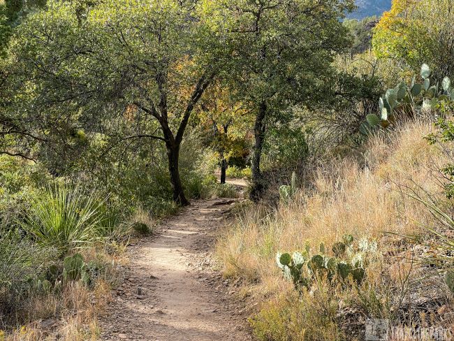
Guadalupe Mountains National Park: Where the Chihuahuan Desert Meets Majesty
Our first stop was the Pine Springs Visitor Center for maps and information. The ranger told us that the 8751 foot Guadalupe Peak is a favorite among hikers and thrill seekers. As Texas’ highest point, it’s a real challenge. Despite our best efforts, we didn’t make it very far before the wind had us turning around. We chose instead to hike McKittrick Canyon. This is a great trail. It was fun going to the Grotto and coming back. A flat trail led us to Pratt’s cabin, which was cool.

Things to See and Do at Guadalupe National Park: Desert Wilderness Wonders
More than just a climber’s haven, this park’s ecosystems range from deserts to pine forests. On our way to visit the Frijole Ranch History Museum, we saw rugged mountains surrounded by deep canyons. Frijole Ranch is just off Hwy 62/180, 1.4 miles north of the Pine Springs Visitor Center. The museum occupies the old ranch headquarters built by the Rader Brothers in 1876. Constructed of local stone, the outbuildings comprise a springhouse and a schoolhouse. The museum has exhibits that explain the human history of the area, beginning with the indigenous people up to and including the building of the ranching community. Interesting story about the natural spring and orchard.

Take the Smith Spring Trail. the short 1.5-mile loop; you can spot wildlife here, like birds, mammals, and reptiles. We saw a golden eagle, but it was too far for photographing. It was getting late in the day; back on the road, we made Brantley Lake State Park just as the sun was setting.

Lakeside Serenity: Camping at Lake Brantley State Park
If you’re yearning for a tranquil retreat surrounded by the beauty of nature, then we recommend camping at Lake Brantley State Park. A 20-minute drive from Carlsbad, one-hour from the caverns, it is truly a hidden gem. The RV camping sites are level concrete pads, each with a covered picnic table, and some have a brick wall to block the wind. On the rise overlooking the lake, it is all rocky desert scrub. We had Site #4 with electric, water, and sewer hookups. The shower house was so warm, almost like a sauna. The bathrooms were very clean. I loved it as the temperatures overnight dropped to freezing. Our water line froze solid, and we had to thaw it out. At night, we could hear coyotes howling in the valley.

We spent two days exploring the joys of lakeside camping and the wonders that await in this haven of serenity. For those eager to stretch their legs, Lake Brantley State Park boasts a network of nature trails. It was quite a hike to the lake shoreline, but it was wonderful exercise, and the trail was easy to follow.

A New Mexico Road Trip to Remember: Carlsbad Caverns National Park
Driving an hour northeast, we experienced the wonders of Carlsbad Caverns National Park. Here you can explore an underground world of impressive rock formations, stalactites, and stalagmites. Take a guided tour of the caverns or explore on your own with a self-guided audio tour.

At Christmas, the park way overcrowded. Arriving early was important, as we wanted to place Sage in the kennel. This is one of the few national parks with dog kennels. Even though we have a Waggle temperature monitor for the travel trailer, it was nice knowing Sage was with us. Dogs are not allowed on trails or in the caverns, so the kennel is great for travelers. This way we could spend the entire day underground doing the Natural Entrance self-guided tour of the Big Room and the King’s Palace tour. The tour does require a reservation through recreation.gov. I recommend purchasing them in advance, as they limit the number of visitors per day.

Carlsbad Caverns: An Adventure Beneath the Surface
The Big Room of Carlsbad Caverns is truly a majestic sight. Stalactites and stalagmites of all shapes and sizes dominate the scene, some reaching astonishing heights. One of my favorite cave features formed by water running down walls is the incredible draperies. To me, these look like cuttlefish swimming. The trail through the Big Room is 1.25-miles and took us about 2 hours to complete. These formations have weird and wacky names, such as the Hall of Giants with its massive stalagmites that truly resemble towering, battling mythical titans. The Rock of Ages is impressive at 43 feet tall and 60 feet wide — a veritable giant within the cave.
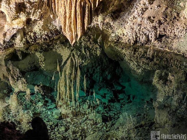
The King’s Palace tour is aptly named, as this chamber features an abundance of “drapery” formations that cascade down the walls like luxurious hangings fit for a royal residence. Starting with only lantern light, we were explorers discovering the cavern for the first time. Our guide explained how Jim White observed bats emerging from the cave, leading to the creation of the cavern. Imaginative cave formations abound on this tour. The “Bashful Elephant” with its dome-shaped body like an elephant’s torso, and a long, pointed projection that curves downward, much like a trunk tucked over its face. At Green Lake, the reflective qualities of the pools create a surreal atmosphere.
Delving into the Beauty of the Sacramento Mountains
The following morning, we broke camp, driving from Lake Brantley State Park. Heading north on Highway 285 took us through an arid Chihuahuan Desert scene. Flat with mostly low-lying sagebrush, it is part of the Permian Basin, one of the most productive oil fields in the United States. Passing through the small town of Artesia, taking US-82 East. The terrain changed as we reached the Sacramento Mountains and the Lincoln National Forest. Finally, pinyon pines and scattered juniper trees and mountain meadows.

Ascending to higher elevations, we were surprised to see snow as we approached Cloudcroft. Cloudcroft is known for outdoor activities such as hiking, mountain biking, and skiing. Sage had never experienced snow, so we stopped to give him a quick bathroom break. He was not impressed at all. I think if the snow had been deeper and fluffier, he might have reacted differently. We had noticed that signs warned of a steep descent into Alamogordo, but we never expected a 6% grade. The panorama was breathtaking; however, towing a trailer on the winding, steep mountain was a little hair-raising, to say the least. In the valley below, in the distance, we saw the gypsum dunes of White Sands. These stand out against the backdrop of the San Andres Mountains.

Seeking the Unexpected in Alamogordo, New Mexico
Reaching the valley floor, we passed through Alamogordo. This town is home to the New Mexico Museum of Space History and the White Sands Missile Range. There are plenty of activities to do in this village, such as visiting the Alameda Park Zoo or the Sunspot Solar Observatory. Unfortunately, on this trip, we just did not have time built into our schedule. We did restock our supplies before heading out to Oliver Lee Memorial State Park.

Discover Oliver Lee State Park: History, Hiking & Scenic Overlooks in the Chihuahuan Desert
Our overnight destination is Oliver Lee Memorial State Park, 12-miles south of Alamogordo. This was a magnificent spot to spend the night near White Sands National Park. We reserved our site (#01) via reserveamerica.com a few months in advance. The campground offers sites for tents and RVs at a reasonable price. The amenities include clean restrooms, hot showers, and a dump station. Each RV site had electricity, water, a fire ring with a grate, picnic table. Surrounded by BLM land, there are off the grid sites for campers. The landscape is quite dramatic as the Sacramento Mountain escarpment rises directly behind the campground, making for beautiful sunsets.

The historic Oliver Lee Ranch House is currently closed for renovations. Instead, we walked to the visitor center to look over the interesting displays on the history of the ranch and the canyon. The Riparian Nature Trail is a short, 0.7 mile peaceful walk. We did not take Sage on this walk, as there was a lot of poison ivy. The boardwalk takes you to a year-round spring. Informational placards highlight the flora and fauna.

Dog Canyon Trail Lincoln National Forest
We started the hike at the trailhead behind the visitor center. The Dog Canyon Trail is a 10.3-mile out & back trail. The cool temperatures made the first mile easier to climb, but it was steep and rocky. Taking the Sage with us (leashed dogs allowed on the trails) we only got as far as the 1.5 mile marker before turning back as the sun was setting. The loose rocks on the trail made trekking in the dark hazardous.

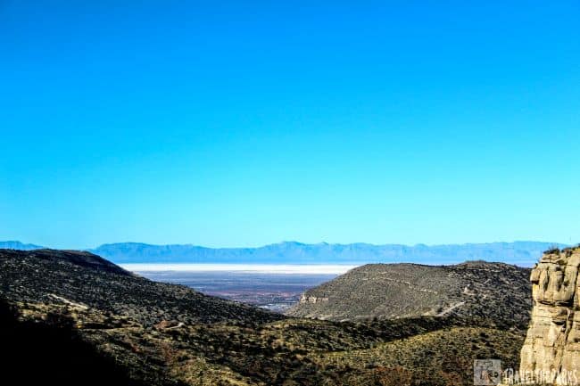
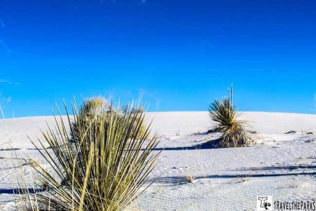
The Enchanting Beauty of White Sands National Park, New Mexico
We got here late in the afternoon. There’s something surreal about the gypsum-rich white dunes that stretch as far as the eye can see. The White Sands National Parkcovers 275 square miles. In terms of area, it dwarfs its nearest competitor in Egypt by over 100 square miles, making it the world’s largest gypsum dunefield.

We’ve climbed dunes in Great Sand Dunes National Park , but this was like nothing we’ve ever seen. It’s cool to touch; the sand doesn’t get hot. There’s no silica in it, just tiny gypsum crystals formed from evaporated seawater. As a result of the unseasonable rains, the sand was hard-packed. Unfortunately, it was not a good sledding day for the many children during their Christmas break. Speed and momentum are also harder to maintain on the crystal surface. It did not seem to deter most from trekking up the dunes in search of the ideal sledding dune.
Hiking the Gypsum Dunes of White Sands: A World of Sparkling Wonder
To truly appreciate the park’s unique ecosystem, explore its trails. The shorter trails, like the Interdune Boardwalk or the Dune Life Nature Trail, are very informative, with educational placards on the diverse adaptations of species that live here.
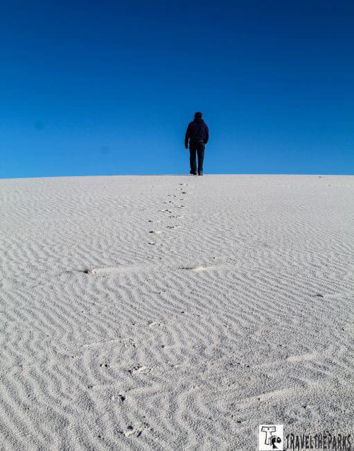
The Alkali Flat Trail is a 4.4-mile loop, and like all trails in the park, it’s dog-friendly. However, we decided to leave Sage in the travel trailer today. Thanks to the Waggle app, we can keep an eye on the trailer’s temperature from our phones. With cooler temperatures this week, the trail was quiet and uncrowded. While there were plenty of footprints in the sand to follow, the orange trail markers made navigation easy. There are enough dunes along the way to find a bit of solitude when you want it.

I must say I don’t understand why they call it flat. It’s not. There are many dunes to climb. This trail is not for the faint of heart. I would not enjoy this trail in the hot summer. Water is crucial in a dry desert environment. Bring enough water for the entire hike, and remember to drink even if you don’t feel thirsty. This is a challenging trail, but the reward is the panoramic views of the San Andres Mountains and the Tularosa Basin.

White Sands Visitor Center: Explore Desert Stories & Dune Adventures on Your Texas-New Mexico Journey
We ended our day, stopping at the visitor center. It is open year-round (except on Thanksgiving and Christmas Day) from 9:00 am to 5:00 pm. The many exhibits here are insightful, with information on the delve into the park’s geology, ecology, and human history. It is worth watching the park film “A Land in Motion” mesmerized me. It showcases the ever-changing landscape. But what fascinated me most was the discovery in 2009 of fossilized human footprints dating back between 21,000 and 23,000 years ago. They are currently the oldest known human footprints in North America.

Heading Back East to Florida
I loathed the idea of heading back home. I was not ready to give up the excitement of exploring unknown places. Alas, we turned back east. After experiencing the rapid descent of US-82, we took the easier scenic Ruidoso Valley for the return trip. First, we had to stop at the roadside attraction PistachioLand to see the world’s largest pistachio. Built in 2007, the 30-foot tall sculpture stands within McGinn’s Country Store and Arena Blanca Winery. It is still a working pistachio farm. It was too early for the store to be open, but we got a few pics before leaving.

The magic of the Ruidoso Valley was the unexpected transition into the Lincoln National Forest. Once again, our views were dominated by ponderosa pines, a welcome change of scenery. It didn’t last as we moved toward Roswell, famous for its UFO-related attractions. Today is one of our longest stretches of road. Spending a full 8 hours on the road. It would have been nice to spend a little time in Roswell. Alas, we move on through, as our final destination is Abilene State Park. The sheer number of windmill farms surprised me on the Texas Ranchlands. Some people find wind turbines visually unappealing. It was fascinating how large they were and the shape of the blades. Finding ways to balance the benefits of clean energy with the protection of traditional land use, ecosystems, and aesthetics remains a key challenge.

Timeless Texas Beauty of Abilene State Park
Abilene State Park, in the heart of West Texas, was a bit of a drive off the beaten path for us. I did like how spread-out the campsites were, and the cost was reasonable. Plenty of nature trails for walking the dog. What’s interesting about this state park are the buildings. The Civilian Conservation Corps workers in the 1930s constructed the facilities, trails, and other amenities. Our stay here was only overnight. It would have been nice to explore more of the trails.

Discovering Outdoor Adventures: Lake Bob Sandlin State Park
Just outside Dallas, Texas, we overnighted at the campground at Lake Bob Sandlin. If you’re looking for a cozy spot to park your travel trailer, Lake Bob Sandlin State Park is a splendid choice. I must say, the Texas Parks and Wildlife Department does an exceptional job of maintaining its parks. Our lakefront site was the perfect place to soak in the natural beauty while having a cold drink after a long day on the road. The trails to the trout pond were wonderful exercise for Sage after being in the truck for such a long period.

Tonight, we have to do laundry and make the trip into the small community of Pittsburg. The tiny hamlet feels like taking a stroll back in time. Definitely, where the charm of a close-knit community and the simplicity of life come together. While waiting for the laundry, we walked to Anvil Brewing Company for a quick bite to eat. This microbrewery has a wonderful ambiance. The décor, featuring reclaimed wood and industrial accents, adds an authentic touch to the brewery’s atmosphere. The brisket was delicious.

Hot Springs National Park: A Blend of Healing Waters & Heritage on Your Epic Southern Road Trip
On our return trip back on this southern road trip to Florida, we took a detour to see Hot Springs National Park in Arkansas. We had the pleasure of experiencing the charm of this hidden gem, and let me tell you, it’s more than just a park. Definitely wasn’t what we expected. The natural scenery of the Ouachita Mountains, hiking trails, and hot springs abound in this park.

This park is not just about the springs; the historic bathhouses add a touch of old-world charm to the experience. Visiting the Fordyce Bathhouse on Bathhouse Row brings back memories of the Golden Age of Bathing. The intricate architecture, stained glass, and marble, reflecting the luxurious experience patrons could expect. A playground for the rich and famous seeking an array of treatments in therapeutic waters. The Buckstaff Bathhouse, still operational today, would have been a pleasant reprieve, but our time is limited, so we only have one day here. Next time, I’d love to indulge in a couple’s bath and massage. We overnighted at the Hot Springs Park KOA, dining out this evening at Taco MOMA, a local authentic Mexican restaurant (Gulpha Gultch Campground canceled our reservation last minute).

Just Unplug-Lake Perry State Lake Campground
On our final day, we found a secluded campground on a 67-acre lake in Mississippi. Just 3 miles south of Beaumont off Highway 98. We discovered this little gem of a park using our RVParky app. Lake Perry State Lake Campground Park does not take reservations, but no worries, as only two other trailers are here tonight. The campground offers 15 campsites with electrical and water hookups. Amenities include a shower house, picnic area, boat ramp, and fishing pier. This is a great option for campers who are looking for a small, quiet, and affordable place to stay in Mississippi. They offer discounted camping for those over 62 and members of the military via an honor box. Again, I wished we had more than a day here, as this park was not far off the highway. It was like being in a different world.

Today we make the last leg of our journey home. From the vast plains of Texas to the enchanting deserts of New Mexico, we have seen some amazing places. The landscape shifts from wide-open spaces to rolling hills as we take the back roads to Mobile, Alabama, trekking onto I-10 to I-75 to find our way home.

Final Thoughts: Exploring 5 National Parks on a Texas and New Mexico Road Trip
This road trip is more than just miles on the odometer. This trip helped us learn a lot about being in close quarters together for a long trip, not to mention having a large German Shepherd. Sage does well in the camper, not so much when his dad gets out of the truck. We had a few hiccups along the way, from the waterline freezing one night to the compromised credit card on Christmas Day. However, we would do it all over again in a heartbeat.
If you’re looking for an epic southwestern national park road trip that takes you through some of the most striking landscapes in Texas and New Mexico, then this it the journey you need to make! Trust me, this road trip was not just a drive; for us, it was a real adventure. We will forever remember this trip in our travellog.
Got any must-see stops or hidden gems on this route? Share them in the comments below! What’s on your ultimate Texas and New Mexico road trip guide?

Fellow Traveller
I would plan at least a week to do San Antonio, Texas. Add in the hill country around Austin is good too.
Travel the Parks
Yes I would agree. Lots to see and do in San Antonio.